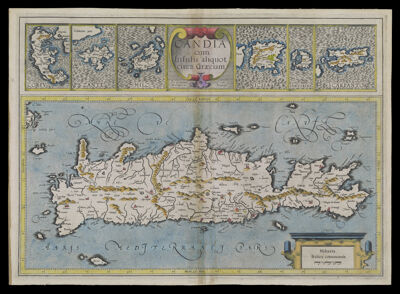
Candia cum Insulis aliquot circa Graeciam per Gerardum Mercatorem, cum privilegio
Creator: Hondius, Jodocus, 1563-1612Publisher: Mercator, Gerhard, 1512-1594Date/Date Range Produced: 1612
Language: LatinRegion Depicted: Crete, GreeceGreeceMap Type: GeographicalPolitical mapsDimensions: H 35 x W 49 cm.
Material Type: PaperHistorical Context: Mercator's son Rumold published his father's atlas in 1595 which lacked detailed maps of Spain and the continents. It was re-issued in 1602 after Rumold's death in 1599. The copperplates of the atlas were sold privately to Jodocus Hondius and Cornelis Claesz. ca. 1604.
LC Call Number: G6812.C7 1612 .O7
OCLC: 699522897
Accession Number: OS-1612-12
Donor: OsherSubjects: Crete (Greece)GreeceHondius, Jodocus, 1563-1612Mercator, Gerhard, 1512-1594