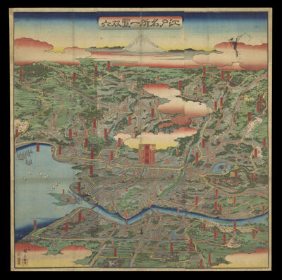
Osher Sheet Map Collection

2,393 results

Map of Massachusetts and Rhode Island
Creator:
Date/Date Range Produced: 1850
Language:
Dimensions: 44 cm. x 71 cm. on sheet 55 cm. x 79 cm.
Printing Process:
Material Type:
Accession Number: OS-1850-28
Donor:
Map of Massachusetts and Rhode Island

The Province of Maine, From the best Authorities
Creator:
Date/Date Range Produced: 1794
Language:
Region Depicted:
Map Type:
Dimensions: 34 cm. x 51 cm. on sheet 39 cm. x 55 cm.
Printing Process:
Material Type:
LC Call Number: G3734 .L4 1794
OCLC: 55520324
Accession Number: OS-1794-20
Donor:
Subjects:
The Province of Maine, From the best Authorities

Upper & Lower Canada.
Publisher:
Date/Date Range Produced: 1838
Language:
Region Depicted:
Map Type:
Dimensions: 36 x 49 cm. on sheet 44 x 55 cm.
Printing Process:
Material Type:
Accession Number: OS-1838-23
Donor:
Subjects:
Upper & Lower Canada.

L'Impero del Giapon : diviso in sette principali parti cioe ochio quanto jetsegen jetsen jamaisoit, xicoco e ximoVenezia 1785 Presso Antonio Zattae Figli con Privilegio dell' Eccino Senato
Creator:
Date/Date Range Produced: 1785
Language:
Dimensions: 37 cm. x 29 cm. on sheet 42 cm. x 34 cm.
Printing Process:
Material Type:
OCLC: 864013640
Accession Number: OS-1785-8
Donor:
L'Impero del Giapon : diviso in sette principali parti cioe ochio quanto jetsegen jetsen jamaisoit, xicoco e ximoVenezia 1785 Presso Antonio Zattae Figli con Privilegio dell' Eccino Senato

Acores Insulae has insulas perlustrauit summaque diligentia accuratissime descripsit et delineavit Ludouicus Teisera Lustanus Regiae Maiestatis cosmographus, anno Christo nato M.D. LXXXIII.
Creator:
Date/Date Range Produced: 1612
Language:
Dimensions: 35 cm x 44 cm on sheet 43 x 54 cm
Printing Process:
Material Type:
LC Call Number: G9130 1612 .O7
OCLC: 819752847
Accession Number: OS-1612-10
Donor:
Acores Insulae has insulas perlustrauit summaque diligentia accuratissime descripsit et delineavit Ludouicus Teisera Lustanus Regiae Maiestatis cosmographus, anno Christo nato M.D. LXXXIII.

Fessae et Marocchi Regna
Creator:
Publisher:
Date/Date Range Produced: 1633
Language:
Region Depicted:
Map Type:
Dimensions: 36 x 57 cm. on sheet 40 x 61 cm.
Printing Process:
Material Type:
LC Call Number: G8230 1633 .M4
OCLC: 864031873
Accession Number: OS-1633-17
Donor:
Subjects:
Fessae et Marocchi Regna

Candia cum Insulis aliquot circa Graeciam per Gerardum Mercatorem, cum privilegio
Creator:
Publisher:
Date/Date Range Produced: 1612
Language:
Region Depicted:
Map Type:
Dimensions: H 35 x W 49 cm.
Material Type:
Historical Context: Mercator's son Rumold published his father's atlas in 1595 which lacked detailed maps of Spain and the continents. It was re-issued in 1602 after Rumold's death in 1599. The copperplates of the atlas were sold privately to Jodocus Hondius and Cornelis Claesz. ca. 1604.
LC Call Number: G6812.C7 1612 .O7
OCLC: 699522897
Accession Number: OS-1612-12
Donor:
Subjects:
Candia cum Insulis aliquot circa Graeciam per Gerardum Mercatorem, cum privilegio

Dvcatvs Geldriae noviffima defcriptio.
Creator:
Publisher:
Date/Date Range Produced: 1629
Language:
Region Depicted:
Map Type:
Dimensions: H 37 x W 48 cm.
Printing Process:
Material Type:
LC Call Number: G6003.G4 1629 .G4
OCLC: 21857082
Accession Number: OS-1629-3
Donor:
Subjects:
Dvcatvs Geldriae noviffima defcriptio.