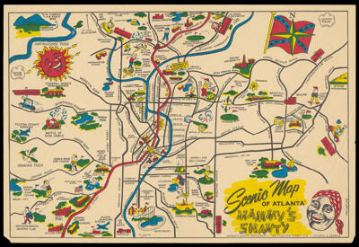
Scenic Map of Atlanta - Mammy's ShantyCreator:Taylor, Fred Region Depicted:Atlanta, Georgia Map Type:GeographicalHistorical mapsPictorial maps Dimensions: 25.5 x 37.5 cm Material Type:Paper Historical Context: JIm Crow laws were state and local laws enacted after the Civil War that enforced segregation in the southern United States. The laws mandated segregation in just about every public place including separate water fountains, segregated schools, theaters and transportation. The Civil Rights Act of 1964 ended legal segregation. LC Call Number: G3924.A8 1945 T3 OCLC: 1289624552 Accession Number: OML-1945-171
War of 1812 the NortheastCreator:Wolfe, David C. Date/Date Range Produced: 2014 Region Depicted:Northeastern States Map Type:GeographicalHistorical maps Dimensions: 35 x 49 cm Historical Context: The War of 1812 started primarily over territorial expansion disputes between the United States and Great Britain and their indigenous allies. It was fought in the American Northeast, Midwest and Southeast and extended into Canada. LC Call Number: G3701.S42 2014 W6 OCLC: 1289635527 Accession Number: OML-2014-36
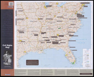
Civil rights map: monuments of the modern civil rights movement of the USA.Publisher:Michelin Travel Publications (Firm) Language:English Region Depicted:United States Map Type:GeographicalHistorical mapsPolitical maps Dimensions: 59 x 66 cm folded to 34 x 12 cm Material Type:Paper Historical Context: The Civil Rights Movement, 1954-1968 was preceded by decades of struggle to end discrimination, racial segregation and disenfranchisement. Led by inspirational leaders such as Dr. Martin Luther King, Jr. and John Lewis and the actions of Rosa Parks who refused to give up her bus seat ignited the movement of protest against inequality and led to the Civil Rights Act of 1964. LC Call Number: G3701.E625 2004 M5 OCLC: 166889260 Accession Number: OML-2004-69 Subjects:Civil Rights Movement


![Civitas Ihervsalem [container test]](https://odyssey.historyit.com/img/thumbnail/Folder.png?no_errors=1)