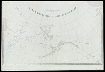
Chart of the NW Coast of America and NE Coast of Asia explored in the years 1778 & 1779. The unshaded parts of the coast of Asia are taken from a MS chart received from the Russians.
Creator: Cook, James, 1728-1779Date/Date Range Produced: 1784
Language: EnglishRegion Depicted: AlaskaAleutian Islands (Alaska)AsiaBering SeaCanadaNorth AmericaPacific OceanRussiaMap Type: GeographicalNautical chartsDimensions: 39 x 67 cm. on sheet 47 x 69 cm.
Printing Process: EngravingMaterial Type: PaperHistorical Context: This chart marks the first time that the coastlines of Alaska and the American northwest were accurately portrayed on a printed map, and is therefore considered to be a map of tremendous historical importance. Produced to meticulously track Captain Cook?s route on his final voyage, this chart reflects his significant contribution to the understanding and mapping of the northern Pacific coasts. When compared with other maps produced during the same year, this chart?s depiction of northwestern landforms, particularly Alaska, are strikingly accurate. The publication of this map was surrounded by controversy; an internal struggle broke out between the editors of Cook?s official account of his third voyage and those who had accompanied Cook on his final voyage and were present at the time the observations were made. A competing chart was constructed by one of Cook?s companions on the voyage, Henry Roberts, but the editors of Cook?s official account successfully suppressed its dissemination. As noted in the map's legend below the title, sections of the Asian coast are drawn from a Russian manuscript map.
OCLC: 221414671
Accession Number: OS-1784-7
Donor: OsherSubjects: AlaskaAsiaBering SeaCanadaExploration and discoveryExplorersMaps--Early works to 1800Nautical chartsNorth AmericaPacific OceanRussia