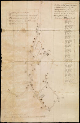
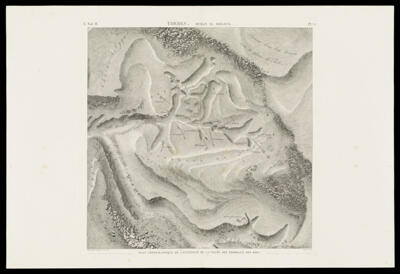
A plan of that part of the District of Alfred within the vicinity of the Meetinghouse, taken for the purpose of shewing & proving the accommodations that can be had there for holding a Supreme Judicial Court, by copy, (signed) Wm. Parsons Survey
Surveyor: Parsons, WilliamDate/Date Range Produced: 1821
Language: EnglishRegion Depicted: Alfred, MaineMap Type: City mapsDimensions: H 77 x W 50 cm.
Printing Technique: ManuscriptMaterial Type: PaperHistorical Context: Maps of place are made to give meaning to one locale so as to distinguish it from all others. Often depicting urban places, such maps generally combine physical and human features of the landscape. Maps of rural places, like maps of property, are generally intended for a few, select users and so remain in manuscript form. This example was made as part of a literal act of place-creation. Alfred, Maine, was originally distinguished as the northern parish of Sanford in 1782, with its own meeting house, acquiring semi-autonomy as the District of Alfred in 1794. The district?s leading land owners, including William Parsons (father or son), worked to have the York County court house moved there. Their effort was successful, and Alfred became the county seat in 1802 and was itself incorporated in 1808. This map was prepared as part of this effort, to delimit Alfred?s core as a site of sufficiently dense settlement to be suitable for hosting the court house.
OCLC: 893908677
Accession Number: OS-1821-8
Donor: OsherSubjects: Alfred (Me.)MaineMaine--MapsManuscript map