

Collection: Osher Map Library Collection
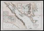
Name: A chart of Frobisher Bay and part of the West Coast of Davis Strait showing the track and discoveries of C.F. Hall on his Franklin research expedition during the years 1860-61-62.
Barcode:
Image Number:
Creator:
Publishing Location:
Notes: Publisher not identified.
Date/Date Range Produced:
Date/Date Range Published:
Language:
Dimensions: 41 x 58
Physical Description: Inset maps: General chart of the Arctic regions; last known location of Franklin's expedition; Kodlunarn or White Man's Island; map of the Countess of Warwick's Sound.
LC Call Number: G3536.S12 1862
OCLC: 948201451
Accession Number: OML-1862-41
Permanent URL: