Sort By:
Creator
Publisher
Date/Date Range Produced1677
Language
Region Depicted
Map Type
Dimensions30 x 38 cm.
Printing Process
Material Type
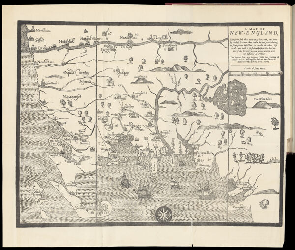
Historical ContextThis was the first map to be cut and printed in New England. It was probably designed by William Hubbard to illustrate his account of King Philip's War (1675-76) in "The Present State of New England : Being a narrative of the troubles with the Indians, 1677." The map was printed from a 1677 woodcut by John Foster, who is considered to be North America's first printmaker. The map has a rather primitive appearance and is acknowledged by its maker to be "less exact."
Oriented with North to the right, the map's vertical lines marked the northern and southern boundaries of the Massachusetts Bay Colony as set forth in the 1629 charter. Rhode Island was depicted as a small island near the base of Cape Cod (lower left), and Martha's Vineyard was labeled Martins Vineyard. The Connecticut River stretched across the top of the map, while the Merrimack River dominated the center, sprouted from a large, island-studded lake (Winnepesaukee). Situated to the far right (north) are "The White Hills" of New Hampshire, later rendered as "The Wine Hills" on a second edition of the map engraved and published in London.
Foster associated the territorial region of "New England" with a historical region of conflict between the English and the indigenous peoples. Numbers keyed to a table in the text indicated the locations of massacres and raids on the English. The following occurred in was is now known as Maine (lower right): No. 42, Kittery; No. 47, York; No. 50, Saco River; No. 51, Wells; No. 54, Scarborough; No. 55, Falmouth (now Portland).
OCLC733577329
Accession NumberOS-1677-3
See Also
Donor
Subjects
Creator
Publisher
Date/Date Range Produced1677
Language
Region Depicted
Map Type
Dimensions30 x 38 cm.
Printing Process
Material Type
Historical ContextThis was the first map to be cut and printed in New England. It was probably designed by William Hubbard to illustrate his account of King Philip's War (1675-76) in "The Present State of New England : Being a narrative of the troubles with the Indians, 1677." The map was printed from a 1677 woodcut by John Foster, who is considered to be North America's first printmaker. The map has a rather primitive appearance and is acknowledged by its maker to be "less exact."
Oriented with North to the right, the map's vertical lines marked the northern and southern boundaries of the Massachusetts Bay Colony as set forth in the 1629 charter. Rhode Island was depicted as a small island near the base of Cape Cod (lower left), and Martha's Vineyard was labeled Martins Vineyard. The Connecticut River stretched across the top of the map, while the Merrimack River dominated the center, sprouted from a large, island-studded lake (Winnepesaukee). Situated to the far right (north) are "The White Hills" of New Hampshire, later rendered as "The Wine Hills" on a second edition of the map engraved and published in London.
Foster associated the territorial region of "New England" with a historical region of conflict between the English and the indigenous peoples. Numbers keyed to a table in the text indicated the locations of massacres and raids on the English. The following occurred in was is now known as Maine (lower right): No. 42, Kittery; No. 47, York; No. 50, Saco River; No. 51, Wells; No. 54, Scarborough; No. 55, Falmouth (now Portland).
OCLC733577329
Accession NumberOS-1677-3
See Also
Donor
Subjects