• About
    • Mission Statement
    • Staff
    • Collections
    • Imaging Services
    • Student Employment
    • History
    • Contact Us
  • Visit
    • Make Appointment
    • Hours
    • Directions
    • Research
    • Group Tours
    • K-12 Field Trips
    • Summer Camp
  • Teach
    • Book a K-12 Visit or Kit
    • Field Trips
    • Classroom Activity Kits
    • Professional Development
    • Downloadables
    • Mapmaking Contest
    • Summer Camp
  • News & Events
  • Blog
  • Search The Collection
  • Browse Maps
  • Exhibits and Reference
    • Gallery Exhibits
    • Map Commentaries
    • Digital Exhibits
    • Reference Books
    • Digital Commons
    • Ask a Librarian
ADVANCED SEARCH
  • HOME |
  • Tag Detail
  • About
    • Mission Statement
    • Staff
    • Collections
    • Imaging Services
    • Student Employment
    • History
    • Contact Us
  • Visit
    • Make Appointment
    • Hours
    • Directions
    • Research
    • Group Tours
    • K-12 Field Trips
    • Summer Camp
  • Teach
    • Book a K-12 Visit or Kit
    • Field Trips
    • Classroom Activity Kits
    • Professional Development
    • Downloadables
    • Mapmaking Contest
    • Summer Camp
  • News & Events
  • Blog
  • Search The Collection
  • Browse Maps
  • Exhibits and Reference
    • Gallery Exhibits
    • Map Commentaries
    • Digital Exhibits
    • Reference Books
    • Digital Commons
    • Ask a Librarian
ADVANCED SEARCH
  • Terms of Use |
  • Privacy Policy |
  • Contact Us

The Harbour of Casco Bay and Islands Adjacent

Showing 1-1 of 1 results

Sort By:

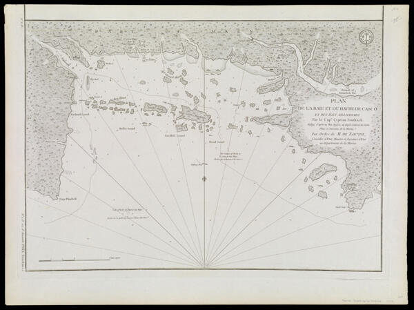
Plan de la Baie et du Havre de Casco et des îles adjacentes, par Cyprian Southack. Rédigé, d'après un plan anglois, au Dépôt général des cartes, plans et journaux de la marine. Par ordre de M. de Sartine, conseiller d'Etat, ministre et secretaire d'Etat au Département de la marine.

CreatorSouthack, Cyprian, 1662-1745

PublisherJno. Mount and Tho. Page

PurveyorJno. Mount and Tho. Page

Date/Date Range Produced1764

LanguageEnglish

Region DepictedCasco Bay, Maine

Map TypeGeographicalNautical charts

Dimensions42 x 53 cm

Printing ProcessEngraving

Material TypePaper

LC Call NumberG3732.C3 S6 1764

OCLC180083605

Accession NumberSM-1764-9

DonorSmith

SubjectsCasco Bay (Me.)Colonial settlements in AmericaFort New Casco (Falmouth, Me.)Jno. Mount and Tho. Page (active 1781 -1784)MaineMaine--Maps


  • About |
  • Visit |
  • Events |
  • Browse |
  • Explore |
  • Teach
  • Terms of Use |
  • Privacy Policy |
  • Contact Us
The digital collections of the Osher Map Library and Smith Center for Cartographic Education are constantly being updated. Please be aware that system development continues as we add new items, revise errant metadata, and fix bugs. Should you experience any issues with the website, please reach out to a staff member.
  • Basic Search
  • Advanced Search
  • Site Search
More +less -