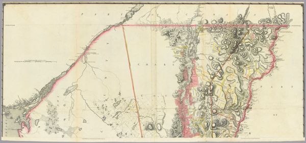
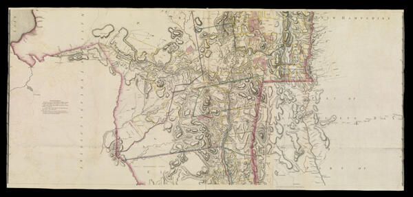
A Chorographical Map of the Province of New-York in North America, Divided into Counties, Manors, Patents and Townships; Exhibiting likewise all the private Grants of Land made and located in that Province; Compiled from Actual Surveys deposited in the Patent Office at New York, by order of His Excellency Major General William Tryon, by Claude Joseph Sauthier, Esqr.CreatorFaden, William, 1749-1836Sauthier, Claude Joseph
PublisherFaden, William, 1749-1836
LanguageEnglish
Region DepictedNew York (State)
DimensionsMap: 62 x 139 cm on sheet: 64.5 x 140.5 cm (middle part of a three part map)
Printing ProcessEngraving
Material TypePaper
OCLC55153720
Accession NumberSM-1779-5.2
See AlsoA Chorographical Map of the Province of New-York in North America, Divided into Counties, Manors, Patents and Townships; Exhibiting likewise all the private Grants of Land made and located in that Province; Compiled from Actual Surveys deposited in the Patent Office at New York, by order of His Excellency Major General William Tryon, by Claude Joseph Sauthier, Esqr. Engraved and published by William FadenA Chorographical Map of the Province of New-York in North America, Divided into Counties, Manors, Patents and Townships; Exhibiting likewise all the private Grants of Land made and located in that Province; Compiled from Actual Surveys deposited in the Patent Office at New York, by order of His Excellency Major General William Tryon, by Claude Joseph Sauthier, Esqr. Engraved and published by William Faden
DonorSmith
Donation DateSep 1st, 2013
SubjectsColonizationSettler-colonialism