
The French Crown paid little attention to the St. Lawrence and northeast North America after the failure of Jacques Cartier’s settlement at Kébec/Québec (1535-41). The fishermen and fur trappers continued on their annual migrations to the St. Lawrence without government interference. This changed soon after 1600, when Henri IV sought once again to encourage permanent French settlement in the region. A small fleet was sent out in 1604-07 under the sieur de Mons to establish this colony somewhere in Acadia. Verrazano had originally called the area of present-day New Jersey ‘Acadia,’ but the area had been steadily pushed eastwards across the map, until it covered the region from Nova Scotia to Maine. De Mons fixed on the estuary of the St. Croix River for his initial base before founding Port Royal in Nova Scotia. Accompanying the fleet was an experienced mariner and soldier, Samuel de Champlain, who had already sailed to New France and back in 1603. Champlain was now given the task of charting the coast of Acadia in detail, from Cape Cod to the Bay of Fundy. In addition to mapping the general course and character of the coast, Champlain made detailed maps of potentially important estuaries and bays. Furthermore, Champlain extended his examination and recording of the landscape to encompass the indigenous vegetation, the Native peoples, and their activities. The results were the first printed large-scale maps and the first detailed ethnographic images produced for the New England region (9-14). Champlain published his journals and maps from his 1604-07 voyages in conjunction with those from his 1608-13 explorations and military campaigns along the St. Lawrence. The general map accompanying Les Voyages de Sieur de Champlain (Paris, 1613) defined the basic geography of the region for much of the seventeenth century (15). Champlain did make some modifications to his maps as he gathered more information on his subsequent voyages of 1615-16 and 1618 (17-20), and the changes were picked up by other mapmakers in Paris. The corpus of Champlain’s maps which has been gathered together here thus constitutes a rich and varied record of the territorial development of New France.
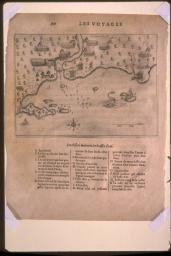
Lescarbot had taken part in de Mons' expedition to Acadia in 1603-07. He wrote the first history of the expedition and its settlements, publishing it in Paris in 1609. For his map, Lescarbot used Champlain's manuscript chart of his explorations (now in the Library of Congress); for the area of New England, his map is therefore very similar to Champlains (15). For the St. Lawrence, however, he had to rely on much older information.
map/7359.0072
MARC LESCARBOT (French, 1590-1630)
FIGVRE DE LA TERRE NEVVE ...
In: Histoire de la Nouvelle-France ..., 2nd ed. (Paris: Jean Millot, 1612)
Woodcut, 17.6 x 42.5 cm
Osher Collection
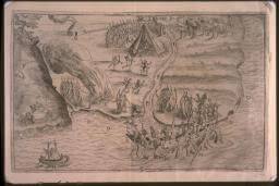
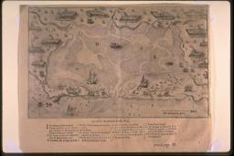
These are the four large-scale maps produced by Champlain's detailed surveys of Maine river estuaries (9-12). The two St. Croix plans were produced during the winter of 1604-05, as de Mons' expedition wintered on the island. The highly accurate maps of the mouths of the Kennebeck and Saco rivers, complete with soundings and sand bars, were made in July 1605. Two more of Champlain's large-scale estuary maps depict sites in Massachusetts, including an attack on a later French expedition to the Cape Cod area (13, 14). Unlike Champlain's charts and regional maps, which were constructed rather abstractly from the distances and directions of his voyages, these large-scale maps were made from Champlain's direct observation and sketching of the landscape itself. The results were highly accurate for such small areas.
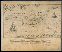
map/369
Isle de sainte Croix
Engraving, 15.1 x 25.4 cm (image)
From: Les Voyages de Sieur de Champlain ... (Paris, 1613)
Osher Collection
map/368
Habitasion de l ile stte croix
Engraving, 11.4 x 15.2 cm (image)
Osher Collection
img/flat/car37.jpg
Qui ni be quy [Mouth of the Kennebec River]
Engraving, 11.1 x 16.1 cm (image)
Browder Collection
img/flat/car38.jpg
Chouacoit [Saco Bay]
Engraving, 11.2 x 15.7 cm (image)
Browder Collection
img/flat/car39.jpg
[Attack at Chatham, Mass., October 15, 1606]
Engraving, 14.8 x 23.7 cm
Browder Collection
img/flat/car40.jpg
Malle Barre [Nauset, Mass.]
Engraving, 14.9 x 24.2 cm (image)
Browder Collection
Champlain merged his general information regarding the New England coast with his later explorations of the St. Lawrence valley (to 1612). The result is his large and ornate general map of New France (15). Even on this map, however, Champlain refers to the manner in which he himself had seen this entire region by including the ethnographic and botanical drawings (15).
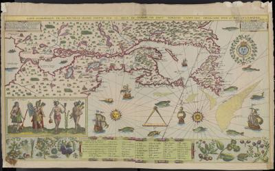
map/4072.0001
SAMUEL DE CHAMPLAIN (French, 1567-1635)
From: Les Voyages de Sieur de Champlain ... (Paris, 1613)
CARTE GEOGRAPHIQUE DE LA NOVVELLE FRANSE . . . faict len 1612
Facsimile of hand-colored engraving, 43.0 x 77.6 cm
Smith Collection
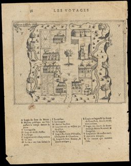
Champlain had applied to New France the European habit of examining Native peoples in the same way as they examined landscapes. He was not alone in this regard. A century later, the tradition was still strong when the baron de Lahontan sketched these ethnographic images of various ceremonies and practices among the Abanaki.
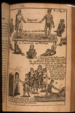
img/flat/car11.jpg
LOUIS DE LAHONTAN (French, 1666-1715)
[Various Ethnographic Images]
From: Nouveaux voyages ... dans l'Amerique septentrionale ... (Paris, 1703, 2 vols.)
Facsimiles of wood-cuts, each 13.4 x 8.5 cm
Smith Collection
After constructing his map of 1612 (15), Champlain returned to New France several times and acquired yet further information. The expansion of the French fur trade led to increasing interaction with, and the gathering of more geographical information from, the Hurons of the St. Lawrence valley. Champlain accordingly updated his map and expanded its geographical scope in this map made to accompany his general history of New France.
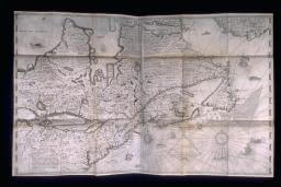
img/flat/car12.jpg
SAMUEL DE CHAMPLAIN (French, 1567-1635)
Carte de la nouuelle france ...
In: Les Voyages de la Novvelle France occidentale ... (Paris, 1632)
Engraving, 52.2 x ca.96.5
Osher Collection
JBoisseau took Champlain's large map of 1632 (17) and reduced it in size to make a more commercially viable product. He was, after all, a commercial cartographer and not a navigator. Although eleven years had passed since Champlain's original map had been published, Boiseau did not try to add any new details or place-names from any of the English or other French voyages. Instead, as has almost always been the case in commercial mapmaking, he simply copied his source directly. One benefit of Boisseau's reduction of Champlain's map is that it is now easier to contrast the configuration of New England on Champlain's original (15b) and later (18a) maps.
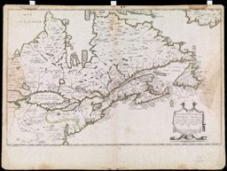
map/425
JEAN BOISSEAU (French, fl. 1637-1658)
DESCRIPTION DE LA NOVVELLE FRANCE
Paris: Jean Boisseau, 1643
Engraving, hand colored, 35.0 x 55.0 cm
Osher Collection
img/flat/car14.jpg
SAMUEL DE CHAMPLAIN (French, 1567-1635)
[La Nouvelle France] faict par le Sr. de Champlain. 1616
Paris, ca.1619
Facsimile of an engraving, 34.5 x 53.7 cm
Smith Collection
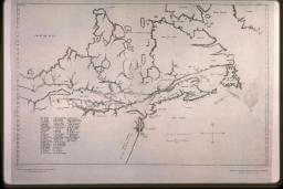
Champlain's cartographic record is made all the more complex by his construction in 1616 of a new regional map of New France, with the addition of his explorations since 1612 (19). The image is clearly similar to what Champlain eventually published in 1632 (17), but is much smaller in scale. The only copy known of this map is now in the John Carter Brown Library, R.I. It is clearly an unfinished printer's proof copy. Despite the date on the map (1616), the evidence of the paper dates this impression of the map to about 1653. That is, Champlain had the new map engraved, but abandoned the project before completion. The copper plate survived, however, and was acquired by Pierre Du Val. Du Val finished the map and published it in 1653; on display here is a later state, from 1677 (20).
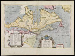
map/1772
PIERRE DU VAL (French, 1618-1683)
LE CANADA faict par le Sr de Champlain ...
Paris, 1677
Engraving, hand colored, 34.8 x 54.3 cm
Smith Collection