

The “Middle Passage” is the name commonly given to the transatlantic shipment of slaves from African ports to the Americas. Because slaves were considered to be trade goods, their owners kept relatively accurate manifests for each ship. These manifests in turn allow good estimates to be calculated for the numbers of slaves shipped from different parts of Africa and delivered to different parts of the Americas. The manifests also reflect the high mortality rates for slaves during the Middle Passage; some scholars have estimated that as many as twenty-five percent died en route.
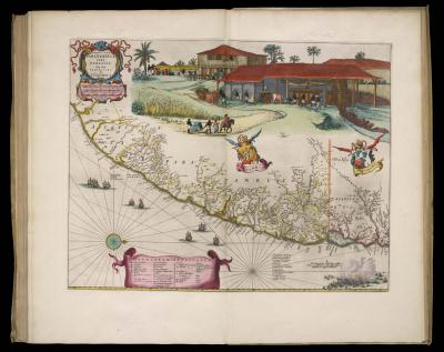
Some of the experiences of African slaves in South America are suggested by these two large maps. The first, showing Pernambuco in northeast Brazil, which was Dutch territory from 1630 to 1654, includes a large, stereotypical image of slaves at work on a sugar plantation. Note that they served as both domestics and farm laborers [34]. The second, showing a wider expanse of northern South America, includes a more subtle trace of the African experience. At the head of the Surinam river, towards the right-hand edge of the area outlined in red, is an interior village labeled “Negros marons.” This was the designation given by the colonists to villages established by escaped slaves [35].
map/14008.0296c
Johannes Blaeu (Dutch, ca. 1599-1673)
Præturæ Paranambucæ pars Borealis una cum
Præfectura de Itâmaracâ
Copper engraving, hand-colored, 41.7 x 53.8cm
In volume 5 of Atlas Maior (Amsterdam, 1662)
Smith Collection

img/flat/exo38.jpg
Jean Baptiste Bourguignon d'Anville (French, 1697-1782)
Amerique Méridionale (northern sheet)
Copper engraving, hand-colored, 41.6 x 77.5cm
In [Atlas Général] (Paris, 1780)
Smith Collection
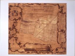
Further traces of the segregated spaces of African slaves in the New World are visible in this set of images. In urban settings, transplanted Africans were not only segregated, they were also spatially marginalized. In this 1764 plan of the French city of New Orleans [36], the guarded huts (‘Q’ at lower left) of the slaves who worked the gristmill (‘N’) were located beyond the carefully laid out grid of streets, beside the quarters of the town guard (‘P’). The sugar plantations of the West Indies formed a cornerstone of the British empire in the eighteenth and nineteenth centuries. Every island was divided up into large plantations [37]. A plan of one such plantation — “Jonas’s Estate” — on the island of Antigua [38] clearly shows the slave quarters (“The Negro Houses” at upper left of plan) close to the master’s house. In contrast to the city plan [36], these plantation slaves were not relegated to the margins of the estate. However, only a few domestic slaves would have been allowed inside the main house.

img/flat/exo39.jpg
Jacques Nicolas Bellin (French, 1703-1772)
Plan de la Nouvelle Orleans
Hand-colored copper engraving, 20.6 x 29.4cm
From volume 1 of Le Petit Atlas Maritime
(Paris: Ministre de la Guerre et de la Marine, 1764)
Smith Collection

img/flat/exo40.jpg
Jacques Nicolas Bellin (French, 1703-1772)
Carte de l'Isle d'Antigue
Hand-colored copper engraving, 19.9 x 14.2cm
From volume 1 of Le Petit Atlas Maritime
(Paris: Ministre de la Guerre et de la Marine, 1764)
Smith Collection
img/flat/exo41.jpg
James Baker, Surveyor General (English, fl. 1820-1852)
A Plan of the Estate called Jonas's Situated in the
Division of North Sound in the Island of Antigua,
The Property of Peter Langford Brooke Esqr.
Facsimile of a manuscript, 59 x 65cm
Surveyed in 1821
Courtesy of the Geography and Map Division
of the Library of Congress
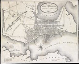
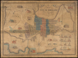
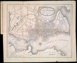
Of the many thousands of African-Americans who escaped slavery in the south before the Civil War, some five hundred found refuge in Portland, Maine. There they found a tolerant community in which they could work for wages. Traces of their presence can be found on early nineteenth-century maps of the city. The African-American community was still too small in 1831 to be noticed on a “Plan of Portland” [39], but the 1856 state of the same map identified the African-American community’s Abyssinian Church as one of the sixteen churches in the city [41]. Indeed, John Cullum’s 1836 “Map of the City of Portland” [40] not only marked the location of the Abyssinian Church (#27) on Sumner Street, below the Observatory and Eastern Cemetery, at right, but pictured it, at left below the vignette of Portland and Bridge Street.
map/12023
D. G. Johnson (American, fl. 1830-1860)
Plan of Portland
Copper engraving transferred to lithograph, ca. 22.9 x 27.9cm
From The Portland Directory (Portland: S. Colman, 1831)
OML Collections
map/11753
John Cullum (American, fl. 1830)
A Map of the City of Portland with the Latest Improvements
Copper engraving, hand-colored, 50.0 x 70.5cm
(Portland, 1836)
OML Collections, Gift of Gary W. Libby, Esq.
map/3628
D. G. Johnson (American, fl. 1830-1860)
S. H. Colesworthy (American, fl. 1850s), editor
Plan of Portland
Copper engraving transferred to lithograph, ca. 22.9 x 27.9cm
From The Portland Directory and Reference Book
(Portland: S. B. Beckett, 1856)
Osher Collection