

The paper companies of northern Maine were formed in the 1890s by combining both private and public lands so as to effect economies of scale. Most important, the new companies replaced the small log dams with very much larger concrete and steel dams, both to make water flow consistent through the summer log drive and to provide electric power for towns and mills. Mechanization in the 1930s required the re-evaluation of the potential of the timber holdings and so led to another round of surveys and assessments.
This section explores the damming of one Maine lake. The U.S. Geological Survey topographic maps, made in cooperation of the State of Maine’s Water Power Commission, show the area on the eve of the dam’s planning and construction [66, 67]. Brassua Lake is at its ‘natural’ level. The dam was finished in 1926. For comparison, an ‘after’ image is provided with a Landsat satellite image [65]. This false-color image shows healthy vegetation in red; snow is white; water is black, but discoloration indicates the beginning of the winter freeze; just to the south of the Moose River, treeless Blue Ridge is prominent; Mt. Kineo is at upper right. The effect of damming is obvious from the increased water surface areas of all of the lakes in the image. In 1920, the U.S. Geological Survey made a very large-scale, plane-table survey of Brassua Lake’s outlet and along the Moose River to the dam site proposed by the Water Power Commission. Topography is shown in one-foot contours; the scale is one inch on the map to one hundred feet on the ground [68, 69]. It provides a detailed view of the largest known prehistoric archaeological site in the Moose River drainage; this site was surveyed and mapped during Central Maine Power’s drawdowns in the 1980s. The USGS survey, for a project destined to change the landscape, was also used for the Brassua Lake quadrangle published in 1923 [66]. This can be seen in the two camps to the north of the outlet — Wallace’s and Payson’s — which also appear on the 1923 topographic quadrangle. The 1923 map’s representation of the pre-dam landscape was thus doomed to immediate obsolescence! Plans for the dam were drawn up based on the plane-table survey. A plan of the proposed dam was traced directly [72]; a view of the completed dam, as seen from the north-east, was also conceptualized [70]. For comparison, 71 is a view of the Brassua dam during the 1987 drawdown. Log towers and buoys demarcate the original channel of the river. The tree stumps are from the original cutting of the shore stand prior the dam construction. Some of the stumps represent growth beginning in the early 1700s and thus reveal climatic patterns for the 18th and 19th centuries.

img/flat/unavailable.png
EROS Data Center
[Brassua Lake, Moose River, and Moosehead Lake]
1 November 1985
Landsat false-color image, 22.7 x 22.7 cm
Hamilton Collection
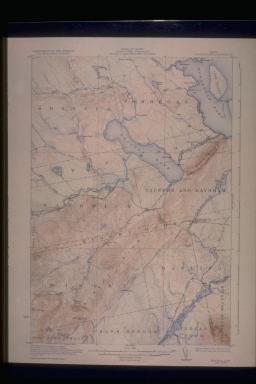
img/flat/mai71.jpg
United States Geological Survey
State of Maine, Water Power Commission
BRASSUA LAKE QUADRANGLE
Washington, DC: USGS, 1923
Color lithograph, 53.0 x 43.0 cm
Osher Collection
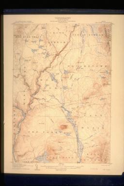
img/flat/mai72.jpg
United States Geological Survey
State of Maine Commissioners
THE FORKS QUADRANGLE
Washington, DC: USGS, 1907
Color lithograph, 53.0 x 43.0 cm
OML Collections
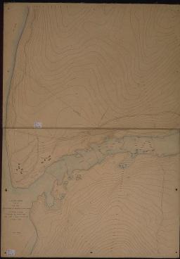
img/flat/mai73.jpg
J. M. Whitman
United States Geological Survey
[Proposed Site for the Dam on the Moose River, Brassua Lake Outlet]
1920
Colored manuscript in two sheets, 42.5 x 60.0 cm each
Maine State Archives
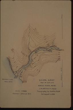
img/flat/mai73.jpg
J. M. Whitman
United States Geological Survey
[Proposed Dam Site on the Moose River, Brassua Lake Outlet]
1920
Facsimile of colored manuscript, 16.0 x 12.5 cm
Maine State Archives
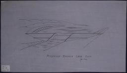
img/flat/mai75.jpg
H. J. W.
Maine Water Power Commission
[Proposed Dam, Brassua Lake Outlet]
1922
Ink on oil cloth, copy of manuscript drawing, 37.8 x 21.7 cm
Maine State Archives

img/flat/unavailable.png
Richard A. Doyle
[Outlet at Brassua Lake]
Color Cibachrome photograph, 16.0 x 24.0 cm
Hamilton Collection

img/flat/mai77.jpg
H. J. W.
Maine Water Power Commission
[Proposed Dam on the Moose River, Brassua Lake Outlet]
1922
Ink on oilcloth, copy of manuscript map, 71.0 x 30.4 cm
Maine State Archives
Increased commercial and tourist use of the Maine Woods decreased the tolerance for forest fires. Seventy fire towers were eventually constructed to assist in controlling the threat across some 10-15 million forest acres. The Squaw Mountain fire tower was the first built in the United States. The tower atop Mt. Kineo was constructed with a 60ft. steel base and was capped with a wooden structure. It was built in 1917 and was jointly funded by the Kennebec Protective Association, Maine Central Railroad, and the Ricker Hotel Company. It was used until 1967, when the fire watch was moved to float planes. The tower was restored by the Maine Conservation Corps in 1993. 73 is a combined topographic map and panoramic view from the Mt. Kineo tower, probably constructed to help in identifying the location of forest fires. An interesting proposal, made in 1945, was for the formation of a "private park" out of extensive lands to the south-east of Moosehead Lake [74]. This would appear to have been related to other projects, such as Governor Baxter's park at Katahdin (1931). Scott Paper merged with Holingsworth & Whitney in 1954; in doing so, Scott Paper acquired H&W's extensive forest lands. Right after the merger, Scott Paper opened up their lands to public access, free of charge. They also gave Lily Bay State Park to the people of Maine. 75 is a promotional map from the early 1960s, showing the extensive range of hunting, fishing, and camping facilities that Scott Paper was making available. Scott Paper steadily increased their land holdings through the 1960s; the merger with S. D. Warren in the early 1970s prompted further acquisitions, giving the company 900,000 acres of land.

img/flat/mai78.jpg
Archie G. Norcross
Views From MT. KINEO FOREST FIRE STATION
Maine Forestry Dept., 1923
Ink and color on oil cloth, 70.0 cm diameter
Maine State Archives
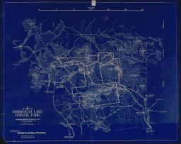
img/flat/mai79.jpg
Sketch of MOOSEHEAD LAKE PRIVATE PARK and Surrounding Points of Interest
Bangor: Prentiss & Carlisle, 1945
Facsimile of blueprint, 69.1 x 86.3 cm
Maine State Archives
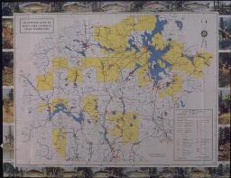
img/flat/mai80.jpg
An Outdoor Guide to Scott Paper Company's Maine Timberlands
Philadelphia: Scott Paper Company, 1962
Offset lithograph, 61.6 x 79.4 cm
Maine Historical Society
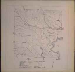
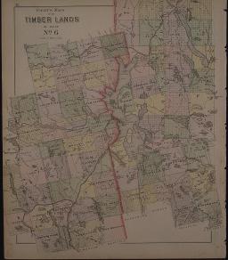
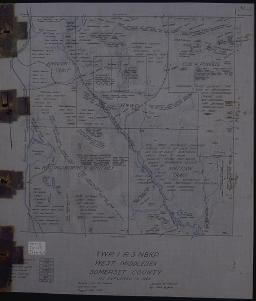
The Northern Timberlands comprised the unincorporated townships of northern Maine. Most of the timberlands in George Colby's map of 1889 [78] eventually became the property of Holingsworth & Whitney and the Great Northern Paper companies. The James W. Sewell Company of Old Town, Me., worked for both H&W and Great Northern Paper in assessing forest resources in terms of quantity, quality, and size. These assessments were greatly aided after the 1930s with the development of aerial photography which allowed for the examination of tree stocks and regrowth areas without the direct observation of every yard of ground. The result is a series of maps with timber classifications, broken down into management areas to facilitate harvesting. 76 and 77 are assessment maps of Brassua Township by the Sewell Company in 1939 and 1950. These maps were originally owned by Walter Craig, superintendent of H&W from 1910 to 1950. 80 and 81 are other Sewell forest assessment maps. 81 includes the area of Austin Cary's 1896-1923 study of forest regeneration after successive cutting. Cary subsequently studied in detail the Spruce Bud Worm and the epidemic of the early 1920s. An H&W employee, Carey undertook his work independently, but it is symptomatic of a growing interest in scientific forest management. Among many studies at the University of Maine of the past and potential future of Maine's timber industry is Max Hilton's 1942 study of pulpwood timbering, which first became a major element in Maine timbering in 1925. Made for Great Northern Paper, Hilton's map [79] shows that company's holdings in the region of the West Branch of the Penobscot during the 1940s.
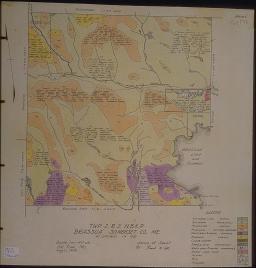
img/flat/mai81.jpg
Frank M. Call
TWP2 R2 NBKP "Brassua" Somerset Co, Me. as Explored in 1939
Old Town: James W. Sewell, 1939
Hand colored lithograph, 44.5 x 44.5 cm
Maine State Archive
img/flat/mai82.jpg
W. Wentworth
Forest Type Map of Brassua
Hollingworth and Whitney Company, 1950
Lithograph, 49.7 x 49.7 cm
Hamilton Collection
img/flat/mai83.jpg
George N. Colby
Colby's Maps of the TIMBER LANDS of Maine, No. 6
In Colby's State of Maine Atlas (Houlton: Colby and Stuart, [1889], 5th ed.)
Lithograph, 42.6 x 36.1 cm
Hamilton Collection

img/flat/mai84.jpg
Great Northern Paper Co.
MAP OF WEST BRANCH WATERSHED
In C. Max Hilton, "Rough
Pulpwood Operating in Northern Maine, 1935-40," The Maine Bulletin 45, no. 1 (1942)
25.3 x 39.0 cm
Hamilton Collection
img/flat/mai85.jpg
Paul Gardner
TWP1 R3 NBKP West Middlesex Somerset County as explored in 1926
Old Town: James W. Sewall, 1926
Ink and color on oil cloth, 37.8 x 42.9 cm
Maine State Archives

img/flat/mai86.jpg
Frank W. Call
TWP2 R7 BKP, WKR Misery Somerset County, Maine as explored during 1938
Old Town: James W. Sewall, 1938
Ink and color on oil cloth, 41.8 x 49.0 cm
Maine State Archives