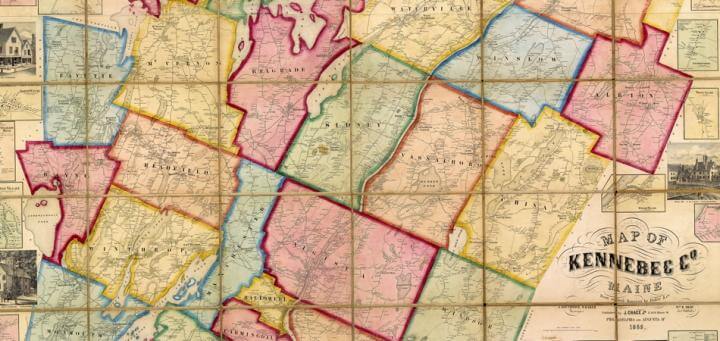

Map of Kennebec Co. Maine From actual Surveys by Baker & Co. | J. Southwick, S. Baker Surveyors | Wm. R. Shaw Ast. Publishr. | Published by J. Chace Jr. 17 & 19 Minor St. Philadelphia and Augusta, Me. 1856
It might be argued that nineteenth-century county maps prefigured modern social media websites like Facebook. Whether by the click of a mouse or the turn of a page, the information displayed and absorbed is fundamentally alike, and so is the viewer’s desire to consume that information. Grounded by geographical statistics, supported by physical markers of place, insulated by names, and decorated with silent indications of status, Facebook and county maps are built upon a common framework designed to transmit information, encourage comparison, and establish an identity forever linked to the past. Most of all, they both promote and affirm a shared sense of community on a regional, local, and individual scale through a mode of interconnectedness experienced like never before.
Maps such as Chase’s 1856 Map of Kennebec County function as important indicators of regional identity and cultural change. With the industrial revolution in full swing in antebellum America, so were anxieties about the encroaching influence of cities, immigrants, and modern modes of transportation. At the same time, the introduction of steam power coupled with advancements in printing technology, allowed map makers to rev up production, diversify, and mass produce maps for an emerging consumer class hungry for anything that may help reestablish a stable sense of place (Brückner 2014, 147). County maps ~ delineating town boarders, roads, homesteads, and points of interest ~ became widely popular in locations like Maine where the anxieties over change and the desire for a close-knit community were particularly strong. Produced for and purchased by the people living in the designated towns, county maps had the intended effect; they invited regional classification, categorization of local communities, and the assessment of property as a marker of individual social standing between neighbors (Lyon-Jenness 2008, 224). On a regional scale, County Maps contributed to the shaping and imagining of place that was carefully framed by a freshly printed, and newly accessible cartographic genre (Conzen 1984).
When comparing the 1856 Map of Kennebec County with, say, the 1857 Map of Cumberland County in the same state, it becomes clear that nineteenth-century county maps were not intended for navigation, but rather a sort of community triangulation. Cartography takes a back seat to boarders and blocks, colors and vignettes, which spill over the ornamental frames like an unruly cut and paste craft project. Clippings of population statistics, religious affiliations, agricultural data, and distance graphics are trimmed down to squeeze between renderings of important buildings, family homesteads, and town centers. The lack of legend, color differentiation, or given rationale for what is included or excluded (like geographical references to the county’s location within the state) reduces the map to a mere patchwork of places, glued together by proximity and camaraderie; and this is exactly the point. With so much noteworthy information to fit into such a “confined” space, Kennebec and Cumberland counties must be very meaningful places ~ especially to those that lived there.
County maps invited the modern notion of “Facebook Stalking,” as it were ~ in the privacy of the home, it was possible to locate, compare, judge, and make assumptions about individuals based on the information displayed, which was often biased in origin. Like a profile picture, the simple outline of an individual house cast assumptions about the aesthetic nature of the dwelling, social status, and occupation that could be determined based on visual qualities alone (see appendix). The details included in the County Maps are what made them so valuable to the individuals that hung them on their walls like oversized ornamental tapestries. The process of recognition ~ of locating one’s homestead on the map and of belonging to a place of significance with history ~ was empowering. Although distinction often came with a price (for enough money, a drawing of your home could be included), the perception was one that ran much deeper and grounded the individual locally and regionally (Lyon-Jenness 2008, 224). On an individual level, county maps thus functioned as a nifty way to define “insider” from “outsider,” “here” from “there,” and as a way to establish a social network based upon individual preferences that centered on community values, a shared regional identity, and a chronicled sense of place.
Further Reading
Brückner, Martin. 2014. “The Lithographed Map in Philadelphia: Innovation, Imitation, and Antebellum Consumer Culture.” Winterthur Portfolio 48, nos. 2–3: 139–61.
Conzen, Michael P. 1984. “The County Landownership Map in America: Its Commercial Development and Social Transformation, 1814–1939.” Imago Mundi 36: 9–31.
Lyon-Jenness, Cheryl. “Picturing Progress: Assessing the Nineteenth-Century Atlas-Map Bonanza.” In Mapping in Michigan and the Great Lakes Region, ed. David I. MacLeod, 209–39. East Lansing: Michigan State University Press.
Megan G. Theriault (MA American and New England Studies; USM 2015)
October 2014
Prepared for ANE 633, “Mapping New England”
Appendix
To explore this idea of “nineteenth-century stalking,” I used the individual homes located in the village of Branch Mills, which appears as a small inset in the lower-left corner of the Map of Kennebec County, to generate assumptions about their appearance. I selected, at random, the “Jose Greely” homestead on Mill Street:

This would seem most likely to be a commanding Federal/Cape style house, because of its rectangular outline with separate buildings added on to its back and sides. I first located the house on Google Maps.

and then used Street View to get a closer look:


I was correct in my assumptions.