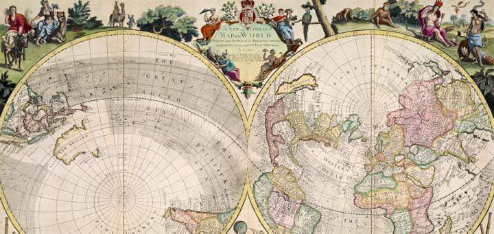
“A New and Correct Map of the World Projected upon the Plane of the Horizon laid down from the Newest Discoveries and most Exact Observations By C. Price Sold by G Willdey at the Great Toy Shop next the Dog Tavern in Ludgate where may be had several other Maps of this Size 1714. | To his Grace Charles Duke of Shrewsbury Lord Chamberlain of the Houshold, and one of the Lords of Her Majtis: most Honble: Privy council Knight of the Garter, &c. This Map is most humbly Dedicated & presented By his Graces Most humble & most Obedient Servt. C. Price”
Copper engraving in two sheets, 62cm x 98.5cm.
There are many things about this beautiful eighteenth-century, British world map that demand our attention. To begin with, it has a distinctive projection: like almost all other world maps produced in Europe between 1650 and 1800, it features two hemispheres, but with a unique twist. Almost all double-hemisphere world maps depicted the Old and New worlds in a “transverse aspect,” with the poles at top and bottom and the equator cutting across the middle; as an example, with a short discussion of the importance of such maps' decorations, see Joan Blaeu’s 1662 world map. But Charles Price (Senior, 1679-1733) used an oblique aspect, in which the hemispheres are projected with London and London’s antipode at their center. In doing so, Price divided the world into land and marine hemispheres.
The map's production history neatly demonstrates how commercially produced maps functioned as commodities, and did so in three different ways. Price had been working with John Senex (1678-1740) to create a “serially published” atlas: people in the “middling sort” could not necessarily afford to buy a large atlas, but they could afford to purchase one in installments, sheet by sheet, over time. (This strategy has been discussed by Varanka 1994, 228-31, and Reinhartz 1997, 33-35.) Indeed, even together, Price and Senex did not have the resources to produce such an atlas all at once (map publishing in London in this period was an undercapitalized and precarious business). Price and Senex would dissolve their partnership in 1710. Price continued to pursue the same business model, but now in conjunction with George Willdey (1676?-1737) and Thomas Brandreth (fl. 1707-1713). Price’s innovative map was first published by this new partnership, probably in 1711 (Armitage and Baynton-Williams 2012, map 5, states 1 and 2). As its title stated, other maps of the same size could be bought from Willdey at “The Great Toy Shop next the Dog Tavern in Ludgate Street,” not far from St. Paul’s cathedral. In other words, the map was created as part of a particular publishing venture that was specifically intended to expand the British market for printed maps.
The Price-Willdey-Brandreth partnership ended just two years later. Willdey took control of the printing plates for Price’s world map and reissued it with substantial changes to its spandrels (Armitage and Baynton-Williams 2012, map 5, state 3). In this respect, the map points to the second, and more general, character of printed maps as commodities. Willdey had allegorical depictions of the four continents added across the top, perhaps in an effort to expand the map’s market by making it serve double duty as a decorative wall map; the allegories were designed and engraved by H. Terrason (fl. 1713-1717). Willdey also had Terrason fill the bottom of the map with a large number of icons depicting the other commodities that Willdey sold. Complex and undoubtedly costly instruments ~ telescopes, a clock, a globe, an armillary spheres, compasses, a gun, a microscope, and a barometer ~ were surrounded by a swarm of lesser manufactures, such as scissors, knives, buckles, monocles, spectacles, tweezers, and razors. The meaning of these images was also inscribed across the map: “These and many other usefull Instruments and Curiositys are made to the Utmost Perfection and Sold wholesale or Retaile by George Willdey.” In fact, Willdey added similar icons and messages to all the maps he sold. Willdey’s interest in maps was not as a geographer: he did not alter or add to the map’s content, not even to change the dedication after the Duke of Shrewsbury’s death in 1718. Rather, Willdey was a merchant who saw printed maps as just another commodity in the consumer’s basket of goods. Willdey, and then his son Thomas, continued to treat the map this way; Hodson (1984-97, no. 183) reproduced Willdey’s advertisement in the Daily Post of 3 February 1731/2, which listed this map (a world map “upon the Horizon”) among many other two-sheet maps.
Finally, the copper plates from which the map was printed were themselves commodities, to be inherited or sold according to the worth of their copper combine with the value added by the engraving. The plates were eventually bought in 1749 or 1750 by Thomas Jefferys (1719-1771), who continued to realize a return on his investment by selling impressions of the map ~ although with the icons of the commodities removed (Armitage and Baynton-Williams 2012, map 5, state 4) ~ until such time as the plates’ added value declined to zero; Jefferys probably then had the printing plates melted down for reuse.
[The lives and careers of Price, Willdey, and Terrason are discussed by Tyacke (1978, 136-38 and 146-48), Hodson (1984-97, 1: nos. 183-84 and appendix I, no. 4), and Worms and Baynton-Williams (2011, 535-36, 722-24, and 656).]
References and Further Reading:
Armitage, Geoff, and Ashley Baynton-Williams. 2012. The World at Their Fingertips: Eighteenth-Century British Two-Sheet Double-Hemisphere World Maps. London: Sylvia Ioannou Foundation and the British Library. [OML ref GA236 .A76 2012]
Hodson, Donald. 1984-97. County Atlases of the British Isles Published after 1703. 3 vols. Welwyn, Herts., and London: The Tewin Press and The British Library.
Pedley, Mary Sponberg. 2005. The Commerce of Cartography: Making and Marketing Maps in Eighteenth-Century France and England. Chicago: University of Chicago Press. [OML ref Z286.M3 P43 2005]
Reinhartz, Dennis. 1997. The Cartographer and the Literati: Herman Moll and His Intellectual Circle. Lampeter, Wales: Edwin Mellen Press. [OML ref GA793.6 .M65 R45 1997]
Tyacke, Sarah. 1978. London Map-Sellers, 1660-1720: A Collection of Advertisements for Maps Placed in the ‘London Gazette,’ 1668-1719, with Biographical Notes on the Map-Sellers. Tring, Herts.: Map Collector Publications. [OML ref Z326 .T92 1978]
Varanka, Dalia. 1994. “Editorial and Design Principles in the Rise of the English World Atlases, 1606–1789.” Ph.D. dissertation. University of Wisconsin–Milwaukee.
Worms, Laurence, and Ashley Baynton-Williams. 2011. British Map Engravers: A Dictionary of Engravers, Lithographers and their Principal Employers to 1850. London: Rare Book Society. [OML ref GA793 .W67 2011]
Matthew H. Edney
February 2013