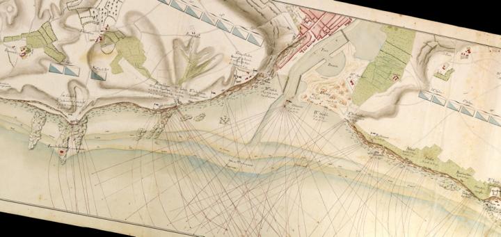

This anonymous manuscript (i.e., hand-drawn) map exemplifies the detailed maps of landscapes and fortifications that were prepared by European military engineers throughout the eighteenth century. The extensive interchange of engineers among the armies of Europe in the seventeenth and eighteenth centuries led to the homogenization of their mapping practices. For Brian Harley, this interchange produced the first coherent, international genre of map making: “in France or in Britain, in India or in North America, the plans exhibit sufficient common traits of technique and design to be logically intelligible in the light of diffusion of a basic style by a highly mobile and professional group of map makers” (Harley 1968, 65-66).
Eighteenth-century military engineers were especially interested in fortifications: they mapped the enemy’s fortifications as a prelude to besieging and destroying them; they mapped their own fortifications in order to plan for their defense. This plan of the environs of Boulogne falls into the latter group. It was probably prepared after May 1803, when Britain once again declared war on France; First Consul Napoleon Buonaparte then assembled an army at Boulogne, which he intended to use in an invasion of Britain.
The plan has the high resolution and large scale (1:10,000) needed to show the landscape in detail. Indeed, the three sheets of paper that form the map have been joined and oriented so as to fit to the approximately north-south trend of the coast. The plan pinpoints the many batteries arrayed along the coast to protect the port and listed the particular kinds of ordnance at each; the red lines arcing out from each define the range of the various mortars and howitzers. Inland, the blue-and-white rectangles indicate the camp lines of the different units of infantry and sappers. The coast and its features are shown in fine detail: the rocks and beaches; the extent of high and low tides, both regular and at the spring equinox; the moles and basins constructed in the ports; the town of Boulogne and outlying villages; and areas of dune and woodland. In short, it presented all that was needed for a commanding officer to plan the defense of this crucial port and stretch of coast against a British invasion.
Anderson, Caroyn Jane. 2009. “State Imperatives: Military Mapping in Scotland, 1689-1770.” Scottish Geographical Journal 125.1:4-24.
Black, Jeremy. 2009. “A Revolution in Military Cartography? Europe 1650-1815.” Journal of Military History 73.1:49-68.
Harley, J. B. 1968. “The Evaluation of Early Maps: Towards a Methodology.” Imago Mundi 22:62-74. [OML journals]
Harley, J. B., Barbara Bartz Petchenik, and Lawrence W. Towner. 1978. Mapping the American Revolutionary War. Chicago: University of Chicago Press. [OML GA405.5 .H37]
Marshall, Douglas W. 1980. “Military Maps of the Eighteenth-Century and the Tower of London Drawing Room.” Imago Mundi 32:21-44. [OML journals]
Matthew H. Edney
January 2013