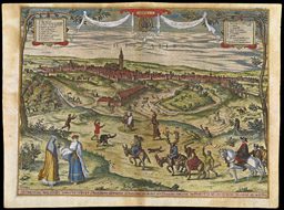
The use of illustrations on or with a map to commemorate an important event has long been common. One such example is this combined map and image by the Danckertses. The map was first published by Justus Danckerts in 1680; Justus’s son, Cornelis Danckerts III, reprinted the map with the addition of an ornate illustration of an army boarding an invasion fleet. This is almost certainly the army of Charles III, archduke of Austria, who in 1703 invaded Spain in pursuit of his claim to the Spanish throne, during the War of the Spanish Succession (a.k.a., Queen Anne’s War; 1701-1714). Charles was able to capture Barcelona, and thereafter ruled Catalonia for seven years. (In 1711, he became Holy Roman Emperor, as Charles VI; his English and Dutch allies withdrew their support and soon thereafter he lost the war). Cornelis’s elegantly executed illustration is undated, but it was probably created to celebrate the fall of Barcelona in 1704.
img/flat/unavailable.png
JUSTUS DANCKERTS
Dutch, 1635-1701
Accuratissima TOTIUS REGNI HISPANIÆ Tabula . .
From: ATLAS, Tot Amsterdam By Justus Danckerts . .
Amsterdam, first published in 1680
Illustrated panel
CORNELIS DANCKERTS III
Dutch, 1664-1717
Theatre de la Guerre en ESPAGNE. et PORTUGAL. Presente a Charles. III. Roy d'Espagne. et des Indes. etc: etc: . . .
The combined map and illustration were printed in Amsterdam, [1703-1706]
Engraving, hand colored, 49.2 x 85.0 cm.