A “cartouche” is the frame used to highlight and emphasize pieces of text on a map. The text might be the map’s title, its place and date of publication, the maker’s name, a dedication, or some explanation of the map’s features. As innately decorative elements, cartouches are designed according to contemporary artistic styles. The cartouche changed as styles fell in and out of fashion. Beginning with the interlaced strapwork and fretwork frames favored by Ortelius and his contemporaries in the mid-16th century, the cartouche took on a more attenuated and asymmetrical shape in the Mannerist style with the next generation of engravers. In the 17th century, map engravers shifted to the more naturalistic imagery favored by Baroque artists, combining motifs drawn from nature with figurative imagery based on classical mythology and allegorical themes. Map engravers drew heavily on pattern books also popular with other artists and craftsmen. These books of style designs and ornamental prints can be considered the “clip art” of their day. Thus the same ornamental motif might be used by cabinet makers, silversmiths, architects, decorative painters, as well as map engravers. In the examples displayed on the wall, the similarities in the cartouches of maps 31 and 34, and of maps 32 and 33, strongly suggest the derivation of entire designs from common sources. With the acceptance of a more restrained and plainer style of mapmaking introduced by French cartographers in the 18th century, the cartouche came increasingly to resemble the title page of a book. Ornamental cartouches were almost completely abandoned by the middle of the 19th century.
map/67.0001
VINCENZO MARIA CORONELLI
Venetian, 1650-1718
PARTE ORIENTALE DELLA SPAGNA . . .
Cartouche: ARME DELLI REGNI DI SPAGNA
From: TEATRO DELLA GUERRA, vol. VIII
Venice, Naples, ca. 1700
Engraving, right: 45.3 x 60.8 cm., left: 44.8 x 60.8 cm.
map/64
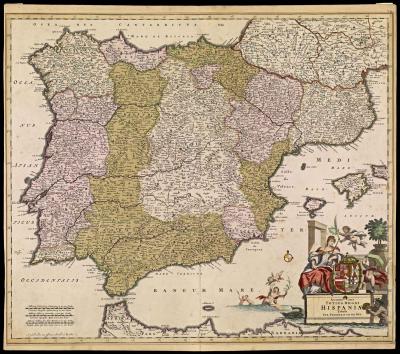
NICOLAES VISSCHER I
Dutch, 1618-1679
or, NICOLAES VISSCHER II
Dutch, 1649-1702
HISPANIÆ ET PORTUGALLIÆ REGNA Per Nicolaum Visscher . . .
From: Atlas Contractus Orbis Terrarum . . .
Amsterdam, ca. 1677
or from, Atlas Minor
Amsterdam, ca. 1689
Engraving, hand colored, 46.2 x 56.6 cm.
https://oshermaps.org/map/59.0001
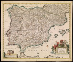
FREDERICK de WIT
Dutch, 1630-1706
Accuratissima TOTIUS REGNI HISPANIÆ Tabula . . .
From: Orbis Maritimus ofte Zee Atlas
Amsterdam, after 1688
Engraving, hand colored, 49.6 x 58.5 cm.
img/flat/spa36.JPG
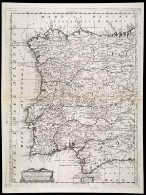
HERMAN MOLL
Dutch, worked in England, fl. 1680-1732
A New and Exact MAP of SPAIN & PORTUGAL Divided into its KINGDOMES and PRINCIPALITIES . . .
From: The WORLD described; or, a New and Correct sett of MAPS
London, ca. 1720
Engraved, hand colored, 61.2 x 98.4 cm