The early means for showing the auto road tended to be descriptive in words and pictures. They seem not to have benefited from the more graphic and comprehensive bird’s eye view, of the bicycle and topographical maps that preceded them. But, the auto presented new opportunities in mapping that would evolve over the next few decades. Mendenhall’s Guide of 1905 represents one of the first efforts intended for the automobile. In booklet form to accommodate written description, it contains maps of urban areas in the manner of a street directory. In effect, it showed the drivable roads at a time when through travel was reserved for railroads [43]. The contemporaneous “Photographic Auto Guide” used photos to show the road as the driver would see it. Despite short written description and simple street maps, the second half of the guide book was required for the return, as the view had changed [44]. The equally ambitious 1907 White Auto Route Book used text along with photos and awarded praise or criticism based on the authors experiences in driving the route. Though anecdotal, such candor would be refreshing in today’s guides. A map is included that shows the broader region of the tour, rather than just the route strip [45]. Various auto clubs distributed route cards to their members on request. Essentially strip maps printed on cardboard, they were inexpensive to produce and easy to use, provided one did not stray off the main route [46, 47]. Better known are the colorful “Tour Maps,” distinguished by their alluring covers [48]. (Examples of these in center flat case.) Made to accompany the AAA “Blue Books”, route numbers correspond to tour segments described in the book. Despite the descriptive detail of these cumbersome volumes, landmarks could go unrecognized and, of course, the road scape would change over time. A standardized system of more permanent markers was needed. B. F. Goodrich, the nation’s most prominent tire company, responded in 1910 with the first of its series of its road-sign route books. This required the placing of “guide posts” from coast to coast, each bearing distance and directional information beneath the Goodrich logo [49]. This system served the automobilist through the decade until the free, folding type oil road maps became readily available. The strip map lingered on, however, as it led the driver past the businesses of the sponsors [50]. The postage stamp on the 1916 Atlantic road map reveals its method of distribution. Taped into a cardboard folder, the map shows all routes in a region, rather than only a specific tour. Maps of this era were small enough to avoid a “folding problem”, but necessarily general, in contrast to earlier tour guides [51]. Again the matter of unmarked roads occurred. As early as the “teens”, highway associations placed distinctive markers along the road [52]. For example a red, white, and blue symbol identified the Lincoln Highway [53, 54]. In 1919 Rand McNally built on this idea by initiating its “Blazed Trail” regional map series. Roads on the map were indexed by number by a symbols key [55, 56]. This required the company to literally blaze the country with poles and paintbrush. Maps were sold to oil companies that overprinted their logos and placed them in distinctive folders. Printing on only one side required a large size thin paper to fit in the small cardboard folder, a combination that rendered them difficult to use while on the road. Proprietary issues showed an Indian marking a trail on a rock overlooking an auto road. Today’s models of autos, such as the Blazer, Tracker and Pathfinder, recall the romantic map titles of this era [57]. A numeric system of marking highways would prove more practical. When the federal interstate system emerged in the mid 1920s, it was quickly adopted by the oil companies and major mapmakers. But, states lacked a uniform system and small map companies were challenged by the change. Crude overprints, conflicting number systems and confusion resulted. The cover illustrations may have been the best part of maps issued by the struggling companies [58, 59, 60]. Colonial Beacon offered clarification in the form of a booklet describing state numbering systems [61]. As the free and systematized oil company road maps became ubiquitous, proprietary issues began to disappear. The innovative Mohawk-Hobbs Guides that featured cross-sectional profiles of the roadway as well as a mile by mile measure of road quality dropped out [62]. Among the oil companies Richfield (west coast) and Calso continued the strip map concept through to the 1950s [63]. Apparently the shape of California lends itself to that style. The post 1970s era of long distance travel along clearly marked interstates rendered the road map less essential and no longer free. Still, one of the most innovative road maps came late in the form of ESSO’s “Upside-down” issue. Intended for “snowbirds” in the Northeast that make the winter trip to Florida, the normal orientation is reversed [64]. Do you find it easier to read?
img/flat/unavailable.png
Mendenhall, C. S. Mendenhall's Guide and Road Map of Eastern Pennsylvania.
Cincinnati, 1911.
img/flat/unavailable.png
Michaels, H. Sargent.
Photographic Runs: Series C, Chicago to Lake Geneva to Delavan, Delavan to Beloit.
Chicago: H. Sargent Michaels, 1905.
img/flat/unavailable.png
White Route Book Number Four: Route of a Tour From Philadelphia to Cape Charles.
Cleveland, Ohio: The White Company, 1907.
img/flat/unavailable.png
Automobile Routes: Manhattan Island (New York City).
[Automobile Route Card]
New York: American Motor League, 1909.
img/flat/unavailable.png
Automobile Routes: New York to New Haven.
[Automobile Route Card]
New York: American Motor League, 1909.
img/flat/unavailable.png
New England Hotel Association Tours.
Touring Bureau of Official Automobile Blue Book for New England Hotel Association, 1911.
img/flat/unavailable.png
Goodrich Route Book: Best in the Long Run, Pennsylvania, East Delaware and Maryland.
Akron, Ohio: The B. F. Goodrich Company, 1916.
img/flat/unavailable.png
Judd, Almon C. The Air Line and Connecting Routes.
Boston: Almon C. Judd, 1924.
img/flat/unavailable.png
The Atlantic Refining Company: Road Map of Pennsylvania and Delaware.
A. B. B. Publishing Company, 1916.
img/flat/unavailable.png
Highway Pole Markers.
[Poster]
Chicago: George F. Cram Company, 1915.
img/flat/unavailable.png
Blazing the Big Trail.
[Advertisement]
Chicago: Burdic Sign Company, 1924.
img/flat/unavailable.png
The Lincoln Highway: A Connected Improved Transcontinental Highway open to Lawful Traffic of all Descriptions, Without Toll Charges.
Detroit: Lincoln Highway Association, 1929.
img/flat/unavailable.png
Tydol Trails: New England Trails Road Marking System and Color Band Route.
Chicago: Rand McNally and Company for Tide Water Oil Company, New York, 1922.
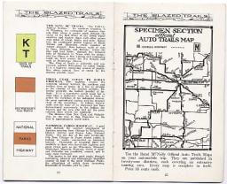
img/flat/roa56.jpg
The Blazed Trails.
Chicago: Rand McNally and Company, 1922.
img/flat/unavailable.png
Rand McNally and Company Official Auto Trails Map: Minnesota.
Chicago: Rand McNally and Company, 1925.

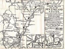
img/flat/roa58.jpg
Mileage Map of the Best Roads of Maine.
The C. M. C. for Hudson- Essex Cars- Hudson Motor Sales Company, 1926.
img/flat/roa59a.jpg
Drive on Concrete, Inter-State Maps Show the Way, Auto Trail Map of New England.
Chicago: Interstate Map Company, 1920.

img/flat/roa60.jpg
The Geographical's Good Road Map of Mass, R. I., and Conn.
Chicago: The Geographical's Publishing Company, 1920.
img/flat/roa61.jpg
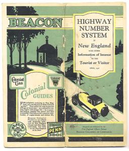
Highway Number System in New England with Other Information of Interest to the Tourist or Visitor, April, 1928.
New England Affairs Bureau and Boston Chamber of Commerce, 1928.

img/flat/roa62a.jpg
Hobbs, Howard F., compiler.
Mohawk Hobbs Grade and Surface Guide.
Akron, Ohio: Tourist Service Department of the Mohawk Rubber Company, 1925.
img/flat/roa63b.jpg
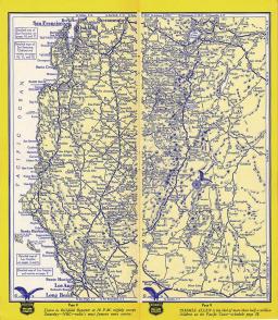
Richfield Strip Maps: California, Oregon, Washington.
San Francisco: Rand McNally and Company for Richfield Oil Company, 1936.
img/flat/roa64a.jpg
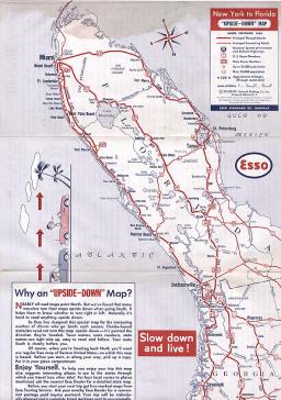
New York to Florida: Upside-Down Map.
Convent Station, NJ: General Drafting Company for Esso Standard Oil Company, 1963.