

It has been said that when Columbus set out on his epic voyage he didn’t know where he was going, that when he arrived he didn’t know where he was, and that after his return he didn’t know where he had been. This satirical statement is true in the sense that Columbus was seeking the East Indies and Asia, was convinced that he had reached those regions, and stubbornly clung to that belief. When subsequent explorations demonstrated that the newly discovered lands constituted a previously unsuspected fourth continent, the impact on the European mind was substantial and varied. Some received the news with consternation, viewing the new lands as a barrier in the way of the hoped-for easy access to the spice islands and the riches of Cathay. Others speculated optimistically about new commercial opportunities – fish, furs, timber, gems, precious metals — and slaves.
For the intellectuals of the time, both religious and lay, the new discoveries came as a shock, since neither science nor scriptural revelations predicted them. The result was a seminal change in the European attitude toward the unknown. The traditional view that unknown regions of the world were filled with horrors to be avoided by reasonable men was replaced by a new spirit of inquiry and systematic exploration. The religious prohibition against probing into matters not revealed by the word of God gave way to the missionary impulse.
Thus began the period of intensive exploration known as the Age of Discovery, during which a new understanding of the configuration of the earth emerged. The maps on display here illustrate the progressive improvement in geographic concepts with particular emphasis on the New World.
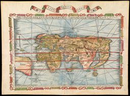
This map was made at the time of the first Columbus voyage. Published in the influential and widely circulated Nuremberg Chronicle, it represents the prevailing European world view at the dawn of the Age of Discovery. The outdated geography is largely from the second century work of Claudius Ptolemy, an indication of the lack of significant progress in the intervening twelve hundred years. The three known continents are crudely depicted, with exaggeration of the eastward extent of Asia and a vast land bridge joining southern Africa to Asia, enclosing the Indian Ocean. Viewing the world from three corners of the map are the sons of Noah - Japhet, Shem, and Ham - each responsible for repopulation of one of the continents according to the biblical account of the Great Flood. Along the left border and on the back of the map are depictions of grotesque humanoid monsters, reflecting the persistence of medieval superstitions. Derived from such early writers as Herodotus, Pliny, and Solinus, and from medieval travelers' tales, these fearsome creatures were believed to inhabit remote regions of the earth and served as a deterrent to all but the most intrepid or foolhardy explorers.

map/238
Secunda etas mundi
Hartmann Schedel.
Nuremberg, 1493. Woodcut.
Osher Collection.
This rare map was published only fifteen years after the first Columbus voyage to the Caribbean and ten years after John Cabot's exploration of the coast of Newfoundland. The maker is said to have sailed on one of the early English voyages to the west, and may have accompanied Cabot; if so, his delineation of the new discoveries may be based on personal knowledge as well as earlier sources.
North America is depicted as a large promontory extending eastward from Asia, with Greenland [Gruenlant] at its northeastern extremity and Newfoundland [Terra Nova] at the southeastern tip. In the Caribbean area a scroll across the western end of a sizable land mass in the approximate position of Cuba states that this is as far as the ships of King Ferdinand ventured, thus reserving judgment on Columbus' conviction that Cuba was part of the Asian mainland.

map/243
Universalior Cogniti Orbis Tabula
Johann Ruysch.
Rome, 1507. Engraving.
Osher Collection.
This is the first printed atlas map devoted to the New World. It has been termed the "Admiral's Map" since it is partly based on information from Columbus, who was known as "Admiral of the Ocean Sea." On his world map of 1507 Waldseemuller had given the name "America" to the large southern land mass in the region, in the mistaken belief that Amerigo Vespucci was its discoverer. Waldseemuller now attempts to correct his error with a legend [just below the equator] crediting Columbus with the discovery of "this land and the adjacent islands," and uses the name "Terra Incognita" in place of America. To no avail; the original name was copied by other mapmakers and was eventually applied, as we shall see, to the entire New World.
The East Coast of the Americas is now beginning to take shape. In fact, features closely resembling Florida and the Gulf of Mexico are depicted, areas not known to have been explored by Europeans until 1513 or later. This has aroused speculation that information may have been obtained from Native American sources or from an unrecorded exploration, probably Portuguese. Cuba ["Isabella"] is correctly shown as an island, in spite of Columbus' insistence that it was part of the Asian mainland.

img/flat/unavailable.png
Tabula Terre Nova
Martin Waldseemuller.
Strasbourg, 1513. Woodcut.
Smith Collection.
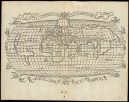
Published seven years after the previous map, this "modern" world map shows little advance in geographic knowledge. In some respects it represents a step backward. For example, Cuba ["Ysabella"] and Hispaniola ["Spagnola"] are depicted in nondescript ovoid form as the only two islands of the West Indies. The westward extent of the map is conveniently limited, presumably because of uncertainty regarding North America. The west coast of South America is, however, rendered in remarkably accurate fashion considering that the results of Magellan's exploration had not yet reached Europe. The name America is prominently placed on the southern continent.
map/251
Tabula Totus Orbis
Laurent Fries. Strasbourg, 1522|35. Woodcut, hand colored.
Osher Collection.
Halting progress is seen here in the depiction of the New World as two misshapen continental landmasses separated by a Central American strait. America is now firmly established as the name of the southern continent. Geographic confusion is evident in the naming of the northern continent. It is labeled "Terra de Cuba," a name used earlier by Waldseemuller in designating the northern region as part of Asia, while other maps of the period apply the name "Cuba" or "Cuba Insula" to the island now known by that name. The creator of this map apparently concluded that Columbus was right in thinking that Cuba was part of the mainland, but wrong in identifying the mainland as part of Asia. In the process he has omitted not only the Island of Cuba but all of the West Indies.
map/250
Typus Cosmographicus Universalis
Joachim von Watte.
Zurich, 1534. Woodcut.
Osher Collection.
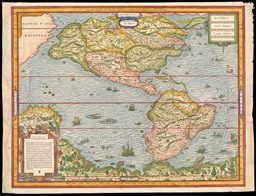
This is the first separate printed map devoted to the New World. While it breaks new ground with its clear depiction of two connected continents separate from all other landmasses, it contains a number of significant errors. The most striking is the large gulf penetrating and nearly bisecting the North American continent; this was reported by Verrazano, who looked westward across the Outer Banks of the Carolinas and mistakenly identified Pamlico Sound as the Pacific Ocean. Other errors include the depiction of Yucatan as an island and the location of Marco Polo's Zipangu [Japan - here labeled Zipangri] nearer to North America than to Asia. The Gulf of Mexico is reasonably well defined. Magellan's strait is shown, as is his flagship Victoria sailing in the ocean to which he gave the name Pacific. The Paria region at the northern extremity of South America carries a legend recalling Columbus's account of abundant gold and pearls, and eastern Brazil contains a cannibal scene. Despite its shortcomings, this was the most widely disseminated and influential map of the Americas during the mid-sixteenth century.

map/294
Die Neuwen Inseln So Hinder Hispanien Gegen Orient Beh Dem Land Indie Ligen.
Sebastian Munster.
Basel, 1540/44. Woodcut.
Osher collection.
Andre Thevet, a Franciscan missionary, was a member of French expeditions to Brazil in 1551 and 1555, and sailed along the east coast of North America on his homebound voyage in 1556. He was personally acquainted with some of the other explorers of America, most notably Carrier. His map, therefore, contains information from his own experience and directly from other observers, as well as that derived from earlier maps. The result is a detailed and remarkably accurate delinea¬tion. The major errors - the misshapen northwest region of North America, the bulging west coast of South America, and the imaginary great antarctic continent - reflect the best geographic thinking of the time. The region and city of "Norimbega" are depicted in the approximate present-day location of Maine. Strangely, Thevet's in-depth knowledge of the native inhabitants of Brazil is not apparent on the map, while the speculative antarctic land abounds with natives and animals. A possible explanation may lie in Thevet's purported belief that the Native Americans were descendants of the lost tribe of Israel.
map/306
Quarte Partie du Monde
Andre Thevet.
Paris, 1575.
Woodcut, hand colored.
Osher Collection.
This map by one of the greatest Dutch cartographers of the sixteenth century presents the most advanced European view of America as the centennial of the Columbus landfall approached. The continental outlines have been improved, especially that of South America. Spanish and French settlements are shown in detail, along with what is probably the first appearance of Chesapeake Bay on a printed map. Several new place names have been added including the first appearance on a printed map of "C. Mendocino" on the California coast. The region and city of "Norumbega" are again seen. At the northern border a body of water resembling Hudson Bay is depicted more than twenty years before Henry Hudson's exploration. Here again, the explanation may lie in a Native American source or an unrecorded European voyage. The mythical antarctic continent persists, apparently uninhabited.
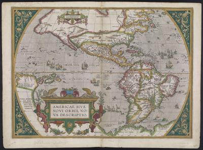
map/1674.0001
Americae Sive Novi Orbis, Nova Descriptio
Abraham Ortelius.
Antwerp, 1587. Engraving, hand colored.
Osher Collection.
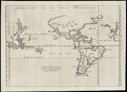
During the late fifteenth century Spain and Portugal competed vigorously for domination of the non-Christian world. An appeal to Pope Alexander VI in 1493 resulted in a papal bull establishing a "Line of Demarcation" 100 leagues west of the Cape Verde Islands; Spain was granted dominion over lands to the west of the line and Portugal over those to the east. This decree by a Spanish-born pope effectively excluded Portugal from the Western Hemisphere and ceded all of the newly discovered lands to Spain. Following negotiations between the two countries, the Treaty of Tordesillas was signed in 1494, repositioning the line to a meridian 370 leagues west of the Cape Verde Islands. As shown on the Herrera map, the eastern tip of Labrador and a substantial portion of Brazil now fell under the dominion of Portugal. An unforeseen consequence of the Line of Demarcation was the impact of its extension to the other side of the earth. The Philippine Islands actually lay on the Portuguese side of the line. However, the Spanish discoverers charted them more than twenty-five degrees east of their true position, thus placing them within the Spanish domain. This map supports the Spanish claims, not surprisingly, since its maker was historiogra¬pher to King Philip II of Spain.
map/381
Description de las Yndias Ocidentalis
Antonio de Herrera.
Madrid, 1601. Engraving.
Osher Collection.
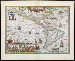
This map presents the early seventeenth century conception of the Americas. The results of recent explorations are seen in the improved geographic delineation and the numerous place names, primarily along the coastlines. The region and city of Norumbega are depicted above a wedge-shaped nameless Penobscot Bay, and the Gulf of Maine is exaggerated in size and displaced south¬ward. Most of the place names are of Spanish origin, except for a few English names in the "Virginia" region and a few French names in eastern Canada. The unexplored interior of North America is covered by a strategically placed large title cartouche and a smaller panel containing a note concerning the unknown far northern regions. Both continents are named: America Septentri-onalis [North America] and America Meridionalis [South America]. Of particular interest on this map are the decorative and informative ethnographic images. At the lower left is an inset scene of Brazilian Indians preparing and consuming a native beverage. A legend explains that Indian maidens chew roots, spit them into a kettle, and after cooking the concoction serve it to the men. In the South Atlantic near the Strait of Magellan, a native family is portrayed in a leather canoe containing a fire. Off the coast of Virginia a dugout canoe, designated as a "boat of Florida," also contains a fire. These depictions are thought to represent "torchlight fishing," in which fire was used to attract fish. In the North Atlantic a Greenlander in a kayak is poised to hurl a harpoon.
These images were drawn from Theodor de Bry's Grands Voyages, an illustrated series of travel accounts which provided Europeans with the first detailed images of Native Americans and their customs. De Bry's engravings constituted a treasure trove of anthropological and ethnological information and served as a principal source for artists and mapmakers for more than a century.
map/384
America
Jodocus Hondius.
Amsterdam, 1606. Engraving.
Osher Collection.