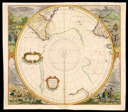
The history of the early mapping of the southern polar regions presents a continual debate between observation and reason, between solely reporting what mariners encountered and turning those partial observations into a general understanding of the region. Henricus Hondius, working in about 1639, abandoned the older concept of terra australis [section 1] for recording a few scattered islands reported by explorers [item 31]. Not that the mariners’ observations were necessarily accurate: Hondius depicted a single chain of islands running across the Pacific from New Guinea to the Straits of Magellan, whose existence was affirmed by a Spanish explorer in 1576. But, for Hondius, the Antarctic itself was nothingness.
The great French geographer Guillaume Delisle (1675–1726) followed suit in 1714, tracing the paths of different explorers across the South Seas. But his son-in-law Philippe Buache (1700–1773) had more conceptual interests and hypothesized, once again, a southern continent [item 32 (on the other side of this wall)]. Buache undermined his father-in-law’s respect for hard data by adding to Delisle’s map of the south pole, within the web of explorers’ tracks, the label Terre Australis Antarctiques Soupçonnées (“Suspected southern Antarctic continent”) [item 33].
The pair to Hondius’s map of the Arctic [item 17 in section 2]. But without economic activity to report, Hondius filled the spandrels with images of the indigenous peoples from South America (and one penguin).

map/4000031
31. Henricus Hondius
Polus Antarcticus
Amsterdam, ca.1639
Even as some geographers scrupulously followed the evidence provided by explorers and other mariners, and so left the Antarctic blank [see item 22, to your left], others continued to speculate about polar regions. In particular, Philippe Buache combined mariners’ observations of ice floes and historical evidence (he traced the extent of terra australis on maps by Ortelius [item 4 in section 1] and others) with his own ideas of the organization of the ranges of mountains around the globe, to hypothesize an Antarctic “Land yet Undiscover’d” embracing a “Frozen Sea as supposed.” Buache thought this southern continent to be analogous to northern Asia, and suggested that it would have similar great rivers: to stress this he also superimposed a heavily shaded outline of Siberia.

map/4000016
32. Philippe Buache
“Chart of the Antarctic Polar Circle, with the Countries adjoining, According to the New Hypothesis of M. Buache”
From: Gentlemen’s Magazine (London, 1763)
Philippe Buache updated his father-in-law’s original 1714 map. It was subsequently reprinted, after Buache’s death, by the Parisian publisher Jean-Claude Dezauche.

map/4000002
33. Guillaume Delisle and Philippe Buache
Hémisphere Méridional pour voir plus distinctement les Terres Australes
Paris: Jean-Claude Dezauche, ca. 1785
Explorers who sailed southern waters relied in large part upon observations of the stars to determine their latitude. Like those who raced for the North Pole, those who would reach the South Pole had to know the stars in order to know when they had, in fact, reached the pole. Boynton’s star chart shows the stars and broad areas of each constellation in the southern sky. The older constellations are figured, such as Lupus (the wolf) and Centaurus. But the southern constellations were recent creations and manifested astronomers’ interests: telescopium (the telescope); triang. aust. (southern triangle); or, across the celestial south pole, octans (the octant).

map/4000035
34. G. W. Boynton
“Circumjacent the South Pole”
From: Bradford Duncan, The Wonders of the Heavens (Boston: American Stationers Company, 1837)
Eventually, after the careful charting of the edges of Antarctica by James Cook, Charles Wilkes, and others [section 5], nineteenth-century geographers had sufficient observations to refute earlier suppositions. This tour du force, made on the eve of the race to the South Pole [sections 6 and 7], presents known areas of land (brown), open water (blue), the extent of winter drift ice (green), permanent ice (white), and in the very center the Unerforschtes Gebiet (the unknown region).

map/4000033
35. Augustus Petermann
Süd-Polar-Karte
From: Stieler’s Hand-Atlas (Gotha: Justus Perthes, 1890), 7