The maps displayed on this wall are generally acknowledged to be cartographic treasures, as judged by conventional standards: they are old, rare, valuable, and historically important. They range in age from approximately 250 years (11) to more than 500 (7). Each has one or more features of historical significance; four of the six (7, 8, 9, 10) can lay claim to a cartographic “first,”while the other two (6, 11) are outstanding examples of notable classes of maps. Each affords a vivid portrayal of a period in history, depicting contemporary thought in a number of spheres, including geographic concepts, navigational methodology, territorial claims, colonial development, and conflicting political statements. In sum, they demonstrate the unique ability of maps to graphically encapsulate and communicate various types of information, and to serve as powerful educational resources.
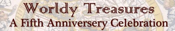
This is a late example of a "portolan chart," used for harbor-finding and coastal navigation. The name is derived from the Italian portolano, a collection of written descriptions and directions for sailing along coastlines "from port to port." First created by Mediterranean mariners in the thirteenth century, these charts represented a fundamental advance in navigation and cartography. They provided remarkably accurate and detailed depictions of coastlines, islands, harbors, and navigational hazards, but no inland features. As in this example, they were drawn in ink of several colors on a specially prepared animal skin called parchment or vellum. Place names were recorded inland at right angles to the coast, with more important places and major harbors in red. A network of "rhumb lines" radiating from central points defined compass or wind directions and served as an aid to navigation. The region portrayed here extends from the eastern extremity of the Black Sea to the Atlantic coasts of the Iberian peninsula and North Africa. The geographic delineation is generally accurate and contains an extraordinary number of coastal place names. The Red Sea, at the southeastern edge of the chart, is appropriately colored and displays a band of dry land commemorating the biblical parting of the waters for the Children of Israel. Decorations include a Madonna and Child (at top, at the "neck"), several elaborate compass roses, numerous flags, castles, fortresses, and a variety of animals, both real and mythical. There are several miniature town views, the most prominent of which are of the important seaports of Venice and Genoa. An inscription on this chart records that it was made in the fortress of Salvador in Messina, Sicily in the year 1583 by Bartolomeo Olives, a member of a distinguished family of Majorcan chart makers. Water staining of its periphery indicates that it was used aboard ship. Indeed, most portolan charts did not long survive the rigors of such use and are therefore now quite rare.
map/319
Bartolomeo Olives
Majorca, ca. 1532-1588
[Portolan chart of the Mediterranean Region]
Majorca, 1583
Manuscript on vellum, 52.5 x 95cm
Osher Collection
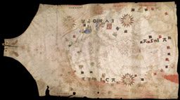
This map of the ancient world is from the first edition of Claudius Ptolemy's monumental Geographia to be printed north of the Alps and the first to contain woodcut maps. Furthermore, this is the first woodcut map to be signed, carrying the inscription "Inscriptum est per Johanne Schnitzer de Armszheim" [Cut by Johanne, woodcutter of Armszheim]. The elegant design, gothic lettering, and distinctive coloring reflect the high quality of contemporary German woodcut illustration. The geographic depiction is the classical second-century Ptolemaic view of the known world, with "Terra Incognita" connecting Africa to Asia, enclosing the Indian Ocean. The only indication of more recently acquired geographical knowledge is a rudimentary portrayal of Scandinavia. The name of the Tropic of Capricorn (near the bottom of the map) was mistakenly printed as "Tropicus Cancri." On this copy of the map the error was corrected in manuscript, probably not long after it was printed. In the atmosphere surrounding the world there are decorative clouds and long-haired "windheads" representing the principal winds, with their Latin names.
map/4692
Nicolas Germanus [Donnus Nicolaus Germanus]
German, ca. 1420-ca. 1489
[Map of the ecumene]
Woodcut, hand-colored, 40.5 x 55.5cm
From: Opvs Donni Nicolai Germani Secvndvm Ptolomevm Finit. (Ulm: Lienhart Holle, 1482)
Osher Collection
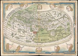
This finely crafted "modern" map of the world was produced less than 20 years after the first Columbian voyage and is characterized by a number of innovative features. It is arguably the first world map to use a heart-shaped (cordiform) projection. It contains the first depiction of Japan in a Ptolemaic geography, and one of the earliest on a western printed map. Place names are printed from movable type set into the woodblock, with red lettering for important places and for winds, possibly representing the first instance of two color map printing. Some recent geographic discoveries are portrayed, most notably a circumnavigable Africa with an open Indian Ocean. However, it is evident that knowledge of the New World is fragmentary. The West Indies are recognizable, with Cuba and Hispaniola ("Ispania") being named. Farther north, "terra laboratorus," referring to the tip of Labrador or Newfoundland makes one of its earliest appearances on a printed map as an island just west of Ireland ("Ibernia Ins."). Another land mass, "regalis domus," representing the discoveries of the brothers Corte Real of Portugal, lies to the west of "terra laboratorus"; its western extent is purposely vague, allowing for the possibility that it may be part of a mainland. Uncertainty regarding the location of Greenland has apparently resulted in its depiction in two different locations, both wrong: as "engronelant" to the north of Scandinavia and as "GRVEN LANT" in northeast Asia directly north of Cathay ("CATAI"). The only new land mass of continental proportions is South America, labeled "TERRA SANCTAE CRVCIS," of which only the eastern portion is portrayed. The notation "canibalus romon" at the northern extremity of South America reflects the prevalent but erroneous impression that cannibalism was widely practiced in the New World.
map/1042
Bernardus Sylvanus
Italian, fl. 1490-1511
[The ecumene and the New World]
Woodcut, printed in two colors, 42 x 56.5cm
From: Clavdii Ptholemaei Alexandrini liber geographiae (Venice: Giacomo Penzio, 1511)
Osher Collection
This is a reduced version of the earliest printed sea chart of the east coast of North America made by an Englishman and the first to use the Mercator projection. Its maker, Sir Robert Dudley (1574-1649), was a colorful figure in Elizabethan England. He was the illegitimate son of Robert Dudley, Earl of Leicester, a favorite of Queen Elizabeth I. Brilliant and ambitious, he became an extraordinarily skilled navigator, engineer, and chartmaker, and aspired to make a major voyage of discovery in the fashion of Sir Francis Drake. The high point of his career came in 1596 when he was knighted for his participation in a successful raid on Cadiz. He fell out of royal favor after a series of misadventures, in particular, his ill-considered support of the Essex rebellion against the Queen in 1601. Leaving England, he assumed the titles of Duke of Northumberland and Earl of Warwick, and entered the service of the Grand Duke of Tuscany. From 1606 until his death in 1649 he lived in Florence and was an influential member of the Court of the Medicis. His major accomplishment during his later years was the production of Dell'Arcano del Mare (Secrets of the Sea), a sea atlas and comprehensive treatise on navigation, shipbuilding, and naval organization. Published in 1646, this was the first sea atlas by an Englishman (expatriate notwithstanding) and the first printed sea atlas with world-wide coverage; it is generally considered to be the most distinguished of its time. The distinctive style of Dudley's charts, typical of Italian baroque art, is attributable to the elegant engraving of Antonio Francesco Lucini. It is believed that Lucini created this reduced version for a never-published "portable" edition of Dudley's sea atlas. This is one of two known examples, and the only copy in a public collection.

map/430
Sir Robert Dudley
English, working in Italy, 1573-1649
Antonio Francesco Lucini
Italian, fl. 1631-1661, Engraver
Carta seconda Generale del' America
Florence: Guiseppe Cocchini, ca. 1661
Copper engraving, 22.5 x 19.5cm
Osher Collection
As the title indicates, this is the first map to be printed in America. It was probably designed by William Hubbard to illustrate his account of King Philip's War (1675-76), and was printed in 1677 from a woodcut by John Foster, America's first printmaker. The map has a rather primitive appearance and is acknowledged by its maker to be "less exact." It is oriented with North to the right, and vertical lines mark the northern and southern boundaries of the Massachusetts Bay Colony as set forth in the 1629 charter. Rhode Island is depicted as a small island near the base of Cape Cod (lower left). Martha's Vineyard is labeled "Martins Vineyard." The large river across the top is the Connecticut, while the river in the center is the Merrimack, arising from a large, island-studded lake (Winnepesaukee). To the right (north) of the latter are "The White Hills" of New Hampshire, later rendered as "The Wine Hills" on a second edition of the map engraved and published in London. The locations of Indian raids and massacres are indicated by numbers keyed to a table in the text. The following occurred in present-day Maine (lower right): No. 42, Kittery; No. 47, York; No. 50, Saco River; No. 51, Wells; No. 54, Scarborough; No. 55, Falmouth (now Portland).
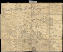
map/492
John Foster
English, 1648-1681
A Map of New England, being the first that ever was here cut.
Woodcut, 30 x 38cm
From: William Hubbard, A Narrative of the Troubles with the Indians In New-England (Boston, 1677)
Osher Collection
The early 1750s were marked by increasingly fierce competition between England and France for control of North American territory and commerce, especially the lucrative fur trading and fishing. Both countries issued proclamations, pamphlets, and maps in support of their conflicting claims, each accusing the other of illegal "encroachments." The French vigorously asserted their sovereignty over the entire watersheds of the St. Lawrence and Mississippi Rivers, including the Great Lakes and Ohio River valley. The British grudgingly conceded only the Canadian regions north of the St. Lawrence River from the Ottawa River ("R. Outaouais") to the Bustard River ("R. Bustard"), the islands in the Gulf of St. Lawrence, a narrow strip of the northern coast of Newfoundland, and lands immediately adjacent to French settlements. These areas, described as "French Possessions and Encroachments," are left uncolored on the map. Tensions steadily mounted until 1755, when the "map wars" gave way to bloody armed conflict: The French and Indian War. This map, made after the onset of hostilities, is perhaps the most blatant of the British propaganda maps. The issuers, a "Society of Anti-Gallicans," make no pretense of impartiality, and present an aggressive and overtly partisan statement of British territorial claims. The title of the map describes the British position as a "Rightful claim as confirm'd by Charters," and refers to the "Encroachment of the French, with the several Forts they have unjustly erected" [emphasis added]. Inscriptions and colored lines define exaggerated British claims which are, in fact, "encroachments" on New France!
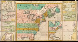
map/692
A Society of Anti-Gallicans A New and Accurate Map of the English Empire in North America
London: William Herbert and Robert Sayer
1755
Copper engraving, hand-colored
Sectionalized on linen, 43 x 81.5cm
Osher Collection