Spanning over two hundred years, these four maps illustrate the evolution of cartography from the artistry of the Dutch “golden age” of the sixteenth and seventeenth centuries to the more rigorously scientific maps of the “age of enlightenment.” With their elevated perspective and foreground compression, these picturesque city views by Braun and Hogenberg (66, 67) encompass many of the elements of the European landscape tradition. During this period, map publishers routinely engaged artists to design the decorative elements for their maps, such as the cartouche in the map of China (68), to increase the visual appeal for their atlases. By the 1790’s, these artistic motifs had largely been dropped from maps as their makers sought to claim a scientific accuracy for their works (69). Long favored by connoisseurs and collectors, these maps exemplify the idea of a cartographic treasure. These four represent a number of such maps which have been donated by collectors to the Osher Map Library. Such gifts have broadened the scope of the collections and allow us to address the needs of different educational communities. Some of these gifts have also enabled us to discover new links between old maps that had hitherto not been realized.
map/3305
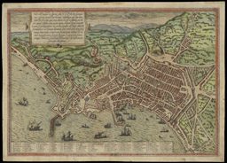
Hæc est nobilis, & florens illa Neapolis, Campaniæ ciuitas
Copper engraving, hand colored with water color, 33.5 x 48cm
From: volume 1 of George Braun and Frans Hogenberg, Civitates Orbis Terrarum, German edition (Cologne: H. von Aich, 1574), pl. 47
Gift of Albert Nickerson

map/12506
Cairus, qvae olim Babylon; Aegypti Maxima Vrbs
Copper engraving, 33 x 48cm
From: volume 1 of George Braun and Frans Hogenberg, Civitates Orbis Terrarum, French edition (Cologne: G. von Kempen, [1575]), pl. 55
Gift in memory of Max Eis

map/3307
Joan Blaeu
Dutch, 1596-1673
China Veteribus Sinarvm Regio nunc Incolis Tame dicta
Copper engraving, hand colored, 41 x 50cm
From: Toonneel des Aerdrycx, oft Nieuwe Atlas (Amsterdam: Joan Blaeu, 1642), vol. 2
Gift of the Gertrude Dodge Estate

map/122
John Cary
English, ca. 1754-1835
A New Map of China, from the Latest Authorities . . . 1801
Copper engraving, hand colored, 47 x 52cm
From: Cary's New Universal Atlas (London, serially published 1799-1808), pl. 46
Howard Collection