

Collection: Story Collection
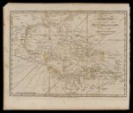
Name: A Correct Chart of the West India Islands engraved for Malham's Naval Gazeteer.
Barcode:
Image Number:
Creator:
Date/Date Range Produced: 1797
Language:
Notes: From John Malham's Naval Gazeteer; Or, Seaman's Complete Guide published first in London by Allen & West in 1795. First American edition published in Boston in 1797.
Physical Description: Map of the West Indies with Texas and Florida shown, as well as part of Central and South America including New Grenada
LC Call Number: GA4900 1797.C6
OCLC: 806273408
Accession Number: ST-1797-16
Donor:
Permanent URL: