

Collection: Textile Museum Collection
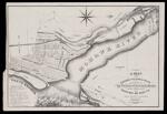
Name: A Map of the Cohoes Village & Falls exhibiting the location of the its canals & basins giving water power which may used to almost any extent on nearly all the adjoining lots
Barcode:
Image Number:
Printmaker:
Publishing Location:
Date/Date Range Published: 1835
Language:
Dimensions: 58 x 86 cm
Brief Description: Map shows the locations of mill companies. Textile manufacturing sparked growth in Cohoes in the 19th century.
LC Call Number: G3804.C6 1835 M5
OCLC: 1030583384
Accession Number: ATH-1835-41
Donor:
Permanent URL: