

Collection: Osher Map Library Collection
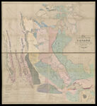
Name: Map of the North West Part of Canada
Barcode:
Image Number:
Dedicatee:
Publishing Location:
Date/Date Range Produced:
Date/Date Range Published:
Language:
Dimensions: 162 x 292 cm
Brief Description: Detailed map of western Canada from Hudson' Bay to the West Coast. Map includes routes of explorers and the changes in political boundaries and forts. Also included is information on games animals, geology and mining, climate and rainfall. Includes Indian population of British North America and of Native Indian tribes.
LC Call Number: G3530 1857.D4
OCLC: 6177856
Accession Number: OML-1857-28
Permanent URL: