

Collection: Osher Map Library Collection
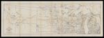
Name: Map Tenth Division Railway Mail Service
Barcode:
Image Number:
Publisher:
Date/Date Range Published: 1908
Language:
Dimensions: H 48 x W 136 cm
Notes: Part of the International Correspondence Schools reference library maps set Map showing railway mail service lines in North Central states Michigan, Wisconsin, Illinois (partial), Iowa (partial), Minnesota, North Dakota, South Dakota, Nebraska (partial), Wyoming (partial), Montana, Idaho (partial); boundaries for Yellowstone National Park marked out) in the early 20th century
Physical Description: 1 map : black and white ; 41 x 131 cm on sheet 48 x 136 cm
OCLC: 830443693
Accession Number: OML-1908-99
Permanent URL: