

Collection: Osher Map Library Collection
Name: Plan of Crawford
Barcode:
Image Number:
Creator:
Publishing Location:
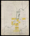
Notes: Manuscript plan of Crawford in Washington County, Maine. Yellow colored areas indicate lottery rights, reserved land and property ownership. Title supplied by cataloger. This is an 1890 copy of the 1840 original. Note above title: "(A Copy.)" Note below title: "The outlines of which and the Lake in particular are from actual survey by the subscriber. Plotted on a scale of 160 rods to an inch. Robbinston Dec 28th 1840. Richard V. Hayden." Below this note is written in red ink: "(A copy March 20 1890 Copied by F.S. Butterfield)"
Date/Date Range Produced:
Date/Date Range Published:
Language:
Dimensions: 50 x 40
Physical Description: 1 manuscript map: color
LC Call Number: G3734.H3 1840
Accession Number: OML-1890-79
Donor:
Permanent URL: