

Collection: Osher Map Library Collection
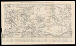
Name: Map no. 1 Carrington's Outline of Indian Operations on the Plains
Barcode:
Image Number:
Publisher:
Publishing Location:
Date/Date Range Published: 1878
Language:
Region Depicted:
Map Type:
Dimensions: 20 x 41 cm
Brief Description: Shows area from Helena, Montana east to the Minnesota-Dakota border and the Union Pacific Railroad, the Dakotas, Montana, Wyoming and Idaho. Includes stations, along the railroad, forts and Colonel Henry B. Carrington's 1866 route.
LC Call Number: G4050 1878
OCLC: 1031394186
Accession Number: OML-1878-68
Permanent URL: