

Collection: Osher Map Library Collection
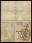
Name: Englands schŭld
Barcode:
Image Number:
Creator:
Publishing Location:
Date/Date Range Published: 1939
Language:
Region Depicted:
Map Type:
Dimensions: 73 x 52 cm folded to 37 x 28 cm
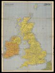
Brief Description: Cover portion of a folding world map for a supplement of the Nazi publication "Illustrierter Beobachter". Cover illustrates a British officer in a sedan chair holding a whip and smoking a pipe while he looks down angrily at the African, Asian and Middle Eastern slaves in chains who carry him. The propaganda objective of the Nazis was to attack "imperialist" England and its guilt. Verso: World map comparing the British empire with Germany, France and Poland. Circled in red is Micronesia. Its islands were once divided between Germany, England and the United States.
LC Call Number: G3201.F33 1939 L3
OCLC: 1280683102
Accession Number: OML-1939-193
Subjects:
Permanent URL: