


Collection: Osher Map Library Collection
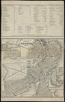
Name: Plan of Boston, 1860.
Barcode:
Image Number:
Creator:
Alternative Title:
Physical Description:
Date/Date Range Produced:
Date/Date Range Published:
Language:
Dimensions: 13 x 13 cm and 11 x 13 cm on sheet 21 x 14 cm
Notes: Inset maps of East Boston and South Boston. Verso: "Map of Boston and Vicinity 1860" Includes index of railroad stations, steam and sailing packets, hotels and places of interest.
OCLC: 586080656
Accession Number: OML-1860-29
Permanent URL: