Sort By:
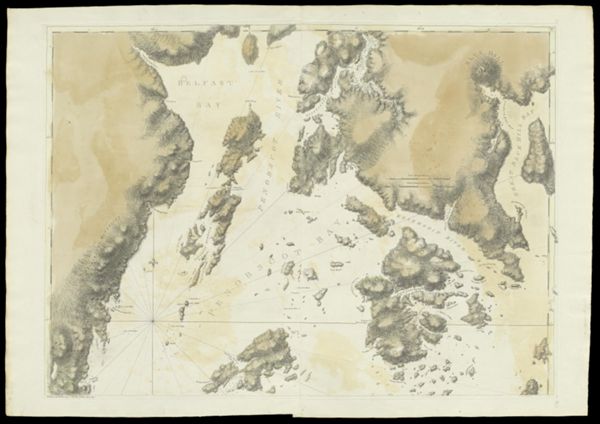
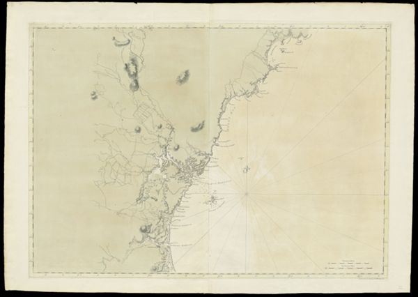
![Chart of Coast from Pemaquid Point to Owl's Head Bay [sheet 2]](https://cdn1.historyit.com/iiif/2/5f34291499c4a6.60628694/685c10bfc61226.46337615.jpg/full/!600,600/0/default.jpg?no_errors=1)
Creator
Publisher
Surveyor
Language
Region Depicted
Map Type
DimensionsChart: 106.5 x 75.5 cm on sheet: 116.5 x 79 cm
Printing Process
Material Type
Accession NumberOS-1777-9
See Also
Donor
Subjects
Creator
Publisher
Surveyor
Language
Region Depicted
Map Type
DimensionsChart: 106.5 x 75.5 cm on sheet: 116.5 x 79 cm
Printing Process
Material Type
Accession NumberOS-1777-9
See Also
Donor
Subjects
Creator
Publisher
Surveyor
Language
Region Depicted
Map Type
DimensionsChart: 106.5 x 75.5 cm on sheet: 116.5 x 79 cm
Printing Process
Material Type
Accession NumberOS-1777-9
See Also
Donor
Subjects
Creator
Publisher
Surveyor
Language
Region Depicted
Map Type
DimensionsChart: 106.5 x 75.5 cm on sheet: 116.5 x 79 cm
Printing Process
Material Type
Accession NumberOS-1777-9
See Also
Donor
Subjects
Creator
Publisher
Surveyor
Language
Region Depicted
Map Type
DimensionsChart: 106.5 x 75.5 cm on sheet: 116.5 x 79 cm
Printing Process
Material Type
Accession NumberOS-1777-9
See Also
Donor
Subjects
Creator
Publisher
Surveyor
Language
Region Depicted
Map Type
DimensionsChart: 106.5 x 75.5 cm on sheet: 116.5 x 79 cm
Printing Process
Material Type
Accession NumberOS-1777-9
See Also
Donor
Subjects
![Charts of the Coast and Harbors of New England [...] [Title page]](https://cdn1.historyit.com/iiif/2/5f34291499c4a6.60628694/684b1c80c16741.57898571.jpg/full/!600,600/0/default.jpg?no_errors=1)
Creator
Publisher
Surveyor
Language
Region Depicted
Map Type
DimensionsChart: 106.5 x 75.5 cm on sheet: 116.5 x 79 cm
Printing Process
Material Type
Accession NumberOS-1777-9
See Also
Donor
Subjects

Creator
Publisher
Surveyor
Language
Region Depicted
Map Type
DimensionsChart: 106.5 x 75.5 cm on sheet: 116.5 x 79 cm
Printing Process
Material Type
Accession NumberOS-1777-9
See Also
Donor
Subjects
Creator
Publisher
Surveyor
Language
Region Depicted
Map Type
DimensionsChart: 106.5 x 75.5 cm on sheet: 116.5 x 79 cm
Printing Process
Material Type
Accession NumberOS-1777-9
See Also
Donor
Subjects
Creator
Publisher
Surveyor
Language
Region Depicted
Map Type
DimensionsChart: 106.5 x 75.5 cm on sheet: 116.5 x 79 cm
Printing Process
Material Type
Accession NumberOS-1777-9
See Also
Donor
Subjects