Sort By:
![Chart of the Coast Goldsborough to Moose Harbor. [Sheet 1 of 3]](https://cdn1.historyit.com/iiif/2/5f34291499c4a6.60628694/685af0a3e46055.23228602.jpg/full/!600,600/0/default.jpg?no_errors=1)
Creator
Publisher
Surveyor
Language
Region Depicted
Map Type
DimensionsChart: 74.5 x 53.5 cm on sheet: 79.5 x 59 cm
Printing Process
Material Type
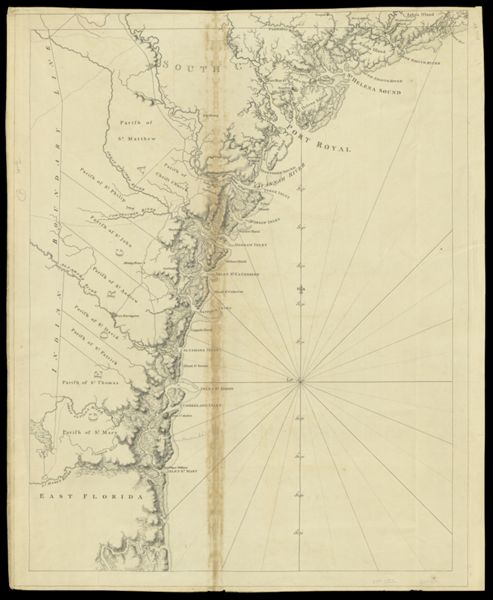
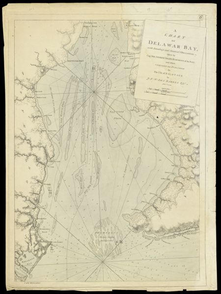
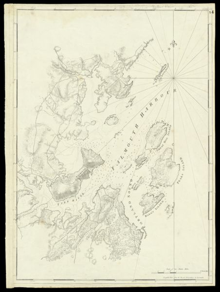
Historical ContextChart of Casco Bay, originally published in London at the beginning of the Revolution, provides the first detailed view of the Portland peninsula, then called Falmouth Neck.
LC Call NumberG3732.P6 D4 1776
OCLC229892607
Accession NumberSM-1776-16
See Also
Donor
Subjects
Creator
Publisher
Surveyor
Language
Region Depicted
Map Type
DimensionsChart: 74.5 x 53.5 cm on sheet: 79.5 x 59 cm
Printing Process
Material Type
Historical ContextChart of Casco Bay, originally published in London at the beginning of the Revolution, provides the first detailed view of the Portland peninsula, then called Falmouth Neck.
LC Call NumberG3732.P6 D4 1776
OCLC229892607
Accession NumberSM-1776-16
See Also
Donor
Subjects
![[Coast of Maine - from Spurwink River to Moose Point] [or, from Musketo Island to Cape Elizabeth, including Kennebec River] [facsimile]](https://odyssey.historyit.com/img/thumbnail/Map.png?no_errors=1)
Creator
Publisher
Surveyor
Language
Region Depicted
Map Type
DimensionsChart: 74.5 x 53.5 cm on sheet: 79.5 x 59 cm
Printing Process
Material Type
Historical ContextChart of Casco Bay, originally published in London at the beginning of the Revolution, provides the first detailed view of the Portland peninsula, then called Falmouth Neck.
LC Call NumberG3732.P6 D4 1776
OCLC229892607
Accession NumberSM-1776-16
See Also
Donor
Subjects
![Chart of the Coast Goldsborough to Moose Harbor [Sheet 2 of 3]](https://cdn1.historyit.com/iiif/2/5f34291499c4a6.60628694/685affc62f78a3.31051526.jpg/full/!600,600/0/default.jpg?no_errors=1)
Creator
Publisher
Surveyor
Language
Region Depicted
Map Type
DimensionsChart: 74.5 x 53.5 cm on sheet: 79.5 x 59 cm
Printing Process
Material Type
Historical ContextChart of Casco Bay, originally published in London at the beginning of the Revolution, provides the first detailed view of the Portland peninsula, then called Falmouth Neck.
LC Call NumberG3732.P6 D4 1776
OCLC229892607
Accession NumberSM-1776-16
See Also
Donor
Subjects
![Chart of the Coast Goldsborough to Moose Harbor [Sheet 3 of 3]](https://cdn1.historyit.com/iiif/2/5f34291499c4a6.60628694/685b021d898ed5.13396848.jpg/full/!600,600/0/default.jpg?no_errors=1)
Creator
Publisher
Surveyor
Language
Region Depicted
Map Type
DimensionsChart: 74.5 x 53.5 cm on sheet: 79.5 x 59 cm
Printing Process
Material Type
Historical ContextChart of Casco Bay, originally published in London at the beginning of the Revolution, provides the first detailed view of the Portland peninsula, then called Falmouth Neck.
LC Call NumberG3732.P6 D4 1776
OCLC229892607
Accession NumberSM-1776-16
See Also
Donor
Subjects
![[Coast of Maine]](https://cdn1.historyit.com/iiif/2/5f34291499c4a6.60628694/624b1308ee1da5.21974005.jpg/full/!600,600/0/default.jpg?no_errors=1)
Creator
Publisher
Surveyor
Language
Region Depicted
Map Type
DimensionsChart: 74.5 x 53.5 cm on sheet: 79.5 x 59 cm
Printing Process
Material Type
Historical ContextChart of Casco Bay, originally published in London at the beginning of the Revolution, provides the first detailed view of the Portland peninsula, then called Falmouth Neck.
LC Call NumberG3732.P6 D4 1776
OCLC229892607
Accession NumberSM-1776-16
See Also
Donor
Subjects
![Notes Biographical and Bibliographical on The Atlantic Neptune [Front cover]](https://cdn1.historyit.com/iiif/2/5f34291499c4a6.60628694/685ec44bb27322.06186736.jpg/full/!600,600/0/default.jpg?no_errors=1)
Creator
Publisher
Surveyor
Language
Region Depicted
Map Type
DimensionsChart: 74.5 x 53.5 cm on sheet: 79.5 x 59 cm
Printing Process
Material Type
Historical ContextChart of Casco Bay, originally published in London at the beginning of the Revolution, provides the first detailed view of the Portland peninsula, then called Falmouth Neck.
LC Call NumberG3732.P6 D4 1776
OCLC229892607
Accession NumberSM-1776-16
See Also
Donor
Subjects