

Collection: Osher Map Library Collection
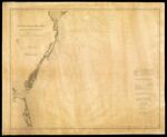
Name: General Chart of the Coast. No. IV, from Cape May to Cape Henry. From a Trigonometrical Survey under the direction of F.R. Hassler and A.D. Bache, Superintendents of the Survey of the Coast of the United States
Barcode:
Image Number:
Publishing Location:
Notes: Chart No. 9. From its Report of the Superintendent of the Coast Survey, showing the progress of the survey during the year 1862 (Washington, Government Printing Office., 1864). The triangulation was executed by E. Blunt, J.E. Johnstone, J. Farley & J.E. Hilgard, Assistants between 1841 & 1853. The topography was executed by F.H. Gerdes, J.C. Neilson, J.J.S. Hassler, G.D. Wise, J. Seib, Assists., N.S. Finney, J. Mechan & C. Ferguson, Sub-Assists., between 1842 & 1859. The hydrography was executed by Lieuts. Comdg. T.R. Gedney, G.S. Blake, G.M. Bache, S.P. Lee, R. Bache, B.E. Sands & J.J. Almy, U.S.N. Assists., between 1841 & 1855. "Description derived from published bibliography"
Date/Date Range Produced:
Date/Date Range Published:
Language:
Dimensions: 72 x 83
Physical Description: 1 chart
OCLC: 43591488
Accession Number: OML-1862-8
Permanent URL: