

Collection: Osher Map Library Collection
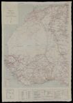
Name: Road Map of West Africa.
Barcode:
Image Number:
Publishing Location:
Date/Date Range Produced:
Date/Date Range Published:
Language:
Dimensions: 77 x 61 cm
Physical Description: Map made for servicemen in World War II to be used in case of capture or being caught behind enemy lines. Shows road and trails and includes sheet assembly diagram.
LC Call Number: G8736.P2 1942
OCLC: 6589841
Accession Number: OML-1942-143
Subjects:
Permanent URL: