

Collection: Osher Map Library Collection
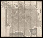
Name: Pianta della citta di Roma
Barcode:
Image Number:
Creator:
Publisher:
Publishing Location:
Date/Date Range Produced:
Date/Date Range Published:
Language:
Dimensions: 74 x 86 cm
Brief Description: Plan of the city of Rome. Rivers are indicated with Roman numerals. Principle monuments and historic sites are keyed to the plan. Engraving. Published by Venanzio Monaldini and engraved by Pietro Ruga.
LC Call Number: G6714.R7 1866 .M6
OCLC: 1004274183
Accession Number: OML-1866-42
Permanent URL: