

Collection: Osher Map Library Collection
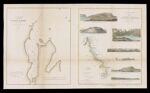
Name: Eclipse Harbor, Labrador/ surveyed by Lieut. Comdg A.Murray U.S.N. ; Sketch showing the geology of the coast of Labrador/by Oscar M. Lieber of the eclipse expedition late state geologist of South Carolina
Barcode:
Image Number:
Creator:
From Atlas:
Publishing Location:
Publisher:
Surveyor:
Date/Date Range Produced: 1860
Language:
Region Depicted:
Map Type:
Dimensions: 2 maps on 1 sheet; 38 x 32 cm and 38 x 31 cm on sheet 43 x 72 cm
Brief Description: Map of Eclipse Harbor, Labrador with depths shown in soundings and sketch of views of coastal Labrador
LC Call Number: G3442.C6 1860 .U55
OCLC: 213815225
Accession Number: OML-1860-53
Permanent URL: