

Collection: Smith Collection
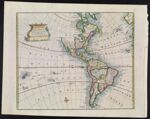
Name: A New General Map of America Drawn from several Accurate particular Maps and Charts and Regulated by Astronomical Observations, by Eman. Bowen.
Barcode:
Image Number:
Creator:
Date/Date Range Produced:
Date/Date Range Published:
Language:
Dimensions: 36 x 48
Printing Process:
Printing Technique:
Material Type:
Notes: Note lower left: "No. 138" Shows the South Pacific Ocean with its islands. Includes boundaries, rivers and early settlements"
Physical Description: 1 map: colored, illustrated
LC Call Number: G3290 .B6 1752
OCLC: 173318526
Accession Number: SM-1752-9
Donor:
Permanent URL: