

Collection: Osher Collection
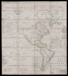
Name: A Chart of North and South America including the Atlantic and Pacific Oceans, with the Nearest Coasts of Europe, Africa, and Asia.
Barcode:
Image Number:
Creator:
Date/Date Range Produced:
Date/Date Range Published:
Language:
Dimensions: 127 cm. x 114 cm.
Notes: Note below neat line: "Published according to Act of Parliament Feb. 19, 1753, by T. Jefferys Geographer to his Royal Highness the Prince of Wales at the corner of St. Martin's Lane Charing Cross." Also includes text, historical and geographical notes, exploration routes and tables of comparative astronomical observations. Includes tables of South America, East side comparative table, East Coast, North Coast of South America, East Coast of North America, comparative tables of Hudson's Straits and Bays, Davis Straits and Baffins Bay. John Green was an alias. He was originally born Bradock Mead in Ireland, likely before 1688.
LC Call Number: G3290 1753 .J4
OCLC: 930611014
Accession Number: OS-1753-2
Donor:
Permanent URL: