

Collection: Osher Collection
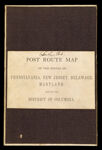
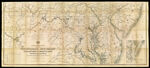
Name: Post route map of the states of Pennsylvania, New Jersey, Delaware and Maryland and of the District of Columbia with adjacent parts of New York, Ohio, Virginia and West Virginia, showing post offices with the intermediate distances and mail routes in operation on the 1st of December 1884 published by order of Postmaster General Walter Q. Gresham under the direction of W.L. Nicholson, topographer P.O. Dept.
Barcode:
Image Number:
Creator:
Date/Date Range Produced:
Date/Date Range Published:
Language:
Dimensions: folded to 21 x 13
Notes: "The first edition was issued in 1869". Includes explanation of mail service and a distance chart. Handwritten on cover "Southern Part."
OCLC: 889350040
Accession Number: OS-1884-68
Donor:
Permanent URL: