

Collection: Osher Collection
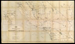
Name: Post route map of the states of California and Nevada showing post offices with the intermediate distances and mail routes in operation on the 1st December 1884 published by order of Postmaster General Walter Q. Gresham under the direction of W.L. Nicholson, topographer P.O. Dept.
Barcode:
Image Number:
Creator:
Date/Date Range Produced:
Date/Date Range Published:
Language:
Dimensions: folded to 21 x 13 cm.
Notes: Includes explanation of mail service. Inset map of San Francisco Bay and outlying areas. Handwritten on cover "Southern Part".
Physical Description: Mounted on linen.
OCLC: 889350784
Accession Number: OS-1885-56
Donor:
Permanent URL: