

Collection: Osher Collection
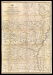
Name: Post route map of the state of Arkansas and of the Indian Territory with adjacent portions of Mississippi, Tennessee, Missouri, Kansas, Texas and Louisiana showing post offices with the intermediate distances and mail routes in operation on the 1st December 1884 published by order of Postmaster General Walter Q. Gresham under the direction of W.L. Nicholson, topographer P.O. Dept.
Barcode:
Image Number:
Creator:
Date/Date Range Produced:
Date/Date Range Published:
Language:
Dimensions: folded to 22 x 14 cm.
Notes: Handwritten on cover: "Eastern Part" and the number "19".
Physical Description: Mounted on linen.
OCLC: 889351006
Accession Number: OS-1884-70
Donor:
Permanent URL: