

Collection: Smith Collection
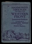
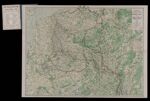
Name: Hammond's Large Scale War Map of the Western Front.
Barcode:
Image Number:
Publishing Location:
Notes: Index and map of the Western Front during World War I. Indicates" Furthest advance of the German Army" and "Battle line July 1st, 1917." Shows railways, canals, aircraft depots, wireless stations, forts, naval arsenals and boundaries; Battle lines overprinted in red.
Date/Date Range Produced:
Date/Date Range Published:
Language:
Physical Description: 1 map: colored
LC Call Number: G5721.S65 1917 .C2
OCLC: 885264879
Accession Number: SM-1917-54
Donor:
Subjects:
Permanent URL: