

Collection: Engass Collection
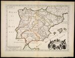
Name: Antiquorum Hispaniae Espiscopatuum Geographica Descriptio.
Barcode:
Image Number:
Creator:
Publishing Location:
Notes: Ecclesiastical map of Spain and Portugal in the late Roman times. Shows specific religious divisions of the Iberian Peninsula after the Roman Empire became Christian in the 4th century A.D. Published 1640 and 1676. Verso: Description of map in Latin
Date/Date Range Produced:
Date/Date Range Published:
Language:
Dimensions: 37 x 50 cm
Printing Process:
Printing Technique:
Material Type:
LC Call Number: G6560 .S3 1640
OCLC: 70191392
Accession Number: ENG-1640-22
Donor:
Permanent URL: