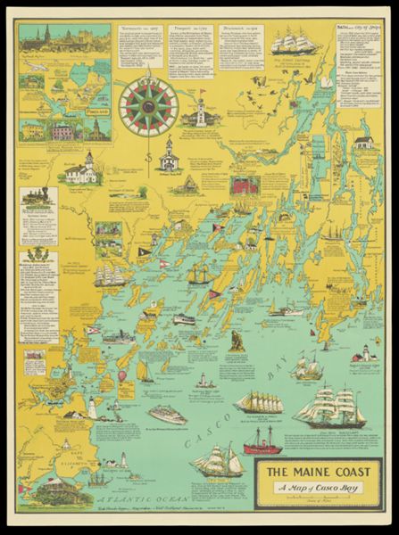
• About
    • Mission Statement
    • Staff
    • Collections
    • Imaging Services
    • Student Employment
    • History
    • Contact Us
  • Visit
    • Make Appointment
    • Hours
    • Directions
    • Research
    • Group Tours
    • K-12 Field Trips
    • Summer Camp
  • Teach
    • Book a K-12 Visit or Kit
    • Field Trips
    • Classroom Activity Kits
    • Professional Development
    • Downloadables
    • Mapmaking Contest
    • Summer Camp
  • News & Events
  • Blog
  • Search The Collection
  • Browse Maps
  • Exhibits and Reference
    • Gallery Exhibits
    • Map Commentaries
    • Digital Exhibits
    • Reference Books
    • Digital Commons
    • Ask a Librarian
ADVANCED SEARCH
  • HOME |
  • Tag Detail
  • About
    • Mission Statement
    • Staff
    • Collections
    • Imaging Services
    • Student Employment
    • History
    • Contact Us
  • Visit
    • Make Appointment
    • Hours
    • Directions
    • Research
    • Group Tours
    • K-12 Field Trips
    • Summer Camp
  • Teach
    • Book a K-12 Visit or Kit
    • Field Trips
    • Classroom Activity Kits
    • Professional Development
    • Downloadables
    • Mapmaking Contest
    • Summer Camp
  • News & Events
  • Blog
  • Search The Collection
  • Browse Maps
  • Exhibits and Reference
    • Gallery Exhibits
    • Map Commentaries
    • Digital Exhibits
    • Reference Books
    • Digital Commons
    • Ask a Librarian
ADVANCED SEARCH
  • Terms of Use |
  • Privacy Policy |
  • Contact Us

The Maine Coast, A Map of Casco Bay

Showing 2-11 of 11 results

Sort By:

The Maine Coast, A Map of Casco Bay

CreatorLepper, Ruth Rhoads

PublisherLepper, Ruth Rhoads

LanguageEnglish

Region DepictedCasco Bay, MaineMaine coastPortland, Maine

Map TypeGeographicalHistorical mapsPictorial maps

Dimensions71 x 53 on sheet: 75 x 55.5 cm

Material TypePaper

LC Call NumberG3732.A5 1985 L4

OCLC1520431709

Accession NumberOML-1985-139

See Also#2 MillA map of the Maine coast from Kennebec to RocklandA Map of the Maine coast from Sheepscot Bay to Muscongus Bay.Maine PlacematMap of the Maine Coast from Rockland, thru Schoodic, to CoreaMap of Western, Central, and Eastern MaineMid-Coast MaineMonhegan Island, MaineThe Maine Coast from Kittery to Cape ElizabethThe Maine Coast, a Map of Casco BayThe Maine Coast, A Map of Casco Bay

SubjectsBath, MaineBowdoin CollegeBrunswick, MaineChurchesFreeport, MaineGray, MaineHomer, WinslowIndigenous peoplesLighthousesLiteratureMachigonneMackworth IslandMaine Historical SocietyNational and state parksPeaks Island, MainePhippsburg, MaineRailroadsSailing shipsYarmouth, Maine


  • 1
  • 2
  • About |
  • Visit |
  • Events |
  • Browse |
  • Explore |
  • Teach
  • Terms of Use |
  • Privacy Policy |
  • Contact Us
The digital collections of the Osher Map Library and Smith Center for Cartographic Education are constantly being updated. Please be aware that system development continues as we add new items, revise errant metadata, and fix bugs. Should you experience any issues with the website, please reach out to a staff member.
  • Basic Search
  • Advanced Search
  • Site Search
More +less -