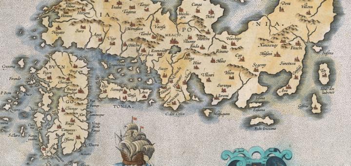

Once a people learn how to visually express their cognitive understanding of the lands and worlds that they inhabit, it is perhaps inevitable that some among them will turn their mind’s eye towards the larger areas surrounding their immediate home. It was precisely such a convergence of the minds of many thinkers and artists that gave rise to the source material from which Abraham Ortelius composed his monumental work, Theatrum orbis terrarium (1570). Amongthe pages of this work,there is an engraved copper print of the rough form of Japan made from a manuscript map originally composed by Portuguese mathematician, cartographer, and royal chart maker Luis Teixeira (fl. 1563-1595: French et al. 1999-2004, 4:257).
The sixteenth-century work in question ~ Iaponiae insulae descriptio ~ is a curious one. It is known in three states: the first, printed in 1595 in a later edition of Ortelius’s Theatrum, shown here; the second, missing the lower left corner, being printed between 1606 and 1608; and the third, with the date removed, being printed after 1612 (Broecke 1996, 216). It features an interesting spatial understanding of three of the central Japanese islands (which Europeans would in time come to know as Kyushu, Shikoku, and Honshu) in relation to the Chinese mainland and an imagined Korean island. While perhaps not the rarest map in the world, it is also interesting in that of these three states only about 3,250 impressions were produced in total (Broecke 1996, 216). Furthermore, the main body of the engraving contained inside the ornamental border features a series of ocean-fairing vessels presumably representing the ongoing explorations of the Dutch and Portuguese into the China Sea and the Pacific Ocean in search of new sources of exotic goods, exploitable foreign markets, and territorial gains. On the reverse, Latin text printed from moveable type explains the nature and value of these islands.
Finally, it is significant to note that what would come to be known as Hokkaido ~ the fourth major island that comprises the modern nation of Japan ~ is completely absent from this map. This fact probably speaks to the understanding, both inside and outside of Japan, that Hokkaido was not yet considered Japanese territory; this position was grounded in the rhetoric surrounding Hokkaido’s indigenous Ainu, who claimed “Ezo” as their ancestral homeland. Hokkaido’s omission is perhaps the map’s most striking element, because it helps to reveal the way in which a foreign group of people approached an unknown land: they hoped to encapsulate and confine the concept of Japan inside the boundaries of a Western cartographic framework without fully appreciating the dynamic complexities of the cultural forces working inside the country. All in all, this map is not only important because it was used in Ortelius’ famous atlas, but because ~ as its several states attest ~ it proved to be an enduring image of a nation that the Western world had only begun to explore and the Eastern world had only begun to understand.
Further Reading:
Broecke, Marcel P. R. van den. 1996. Ortelius Atlas Maps: An Illustrated Guide. ’t Goy-Houten, Neth.: HES & De Graff.
French, Josephine, et al., eds. 1999-2004. Tooley’s Dictionary of Mapmakers. Revised ed. 4 vols. Tring, Herts.: Map Collector Publications.
Philip Rotolo (BA History; USM 2014)
November 2013
Prepared for GEO 207, “Map History”