
If I forget thee O Jerusalem, let my right hand lose her cunning. If I do not remember thee, let my tongue cleave to the roof of my mouth; if I set not Jerusalem above my chiefest joy. [Psalms 137:5-6]
Maps contribute greatly to the understanding of history by providing an essential spatial context for events. They are commonly regarded as scientific documents that objectively portray geographic reality. There are several reasons why this may not be the case. Mapmaking requires a deliberate selection of the information to be included (and excluded) and the manner in which it is depicted. This is a subjective process reflecting, in addition to geographic knowledge and technical expertise, the cultural background, convictions, and biases of the mapmaker. Such considerations assume more than usual importance in the case of Jerusalem because of its special status as a sacred city and the strong feelings that it evokes. The maps and plans displayed here illustrate some significant events and periods in the history of Jerusalem. Most of these images were created long after the events and periods they purport to illustrate, by makers who had never visited Jerusalem. They were based on secondary sources such as the Bible and early historical accounts, sometimes supplemented by eyewitness reports of travelers, and almost always by a liberal dose of imagination. Sites regarded as important for religious or historical reasons were depicted, often on a disproportionately large scale, to the exclusion of those deemed less important. Landmarks and holy sites whose correct locations were unknown or speculative were confidently placed in their imputed or “traditional” positions. Time was often “telescoped” to create multiepochal portrayals in which places and events from various eras were depicted as though they were contemporaneous; e.g., Solomon’s Temple and the Crucifixion. Despite their faults, these documents provide fascinating and informative insights into the history of Jerusalem. It will be noted that some of the maps are designed with east or west at the top, instead of north. Eastern orientation was customary on early maps before the modern convention of placing north at the top was adopted. Furthermore, pilgrims usually reached Jerusalem by traveling eastward from Mediterranean ports, so that their first view of the city was toward the east. The opposite view, toward the west from the Mount of Olives, was favored by artists and tourists because it afforded a panorama of the old city and its principal holy sites; in addition, the Mount of Olives was believed to be the traditional site from which Jesus viewed the city [Luke 19:41].
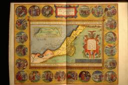
This map is an acknowledged masterpiece of composition and engraving by the great Flemish cartographer, Abraham Ortelius. It illustrates the Biblical story of Abraham the Patriarch as recorded in Genesis. The decorative border contains twenty-two medallions portraying scenes from the life of Abraham, such as the sacrifice of Isaac. The central portion is in the form of a tapestry containing two maps. The small inset map at upper left traces Abraham's wanderings from Ur in the Euphrates Valley to the Promised Land of Canaan; several cities are named, the most prominent of which is Salem, the future Jerusalem. The larger map depicts the ancient tribal divisions of the Land of Canaan as described in Genesis; the largest city (as judged by its symbolic representation) is named "Salem, et Ierusalem."

img/flat/jer01.jpg
ABRAHAM ORTELIUS
Flemish, 1527-1598
ABRAHAMI PATRIARCHAE PEREGRINATIO, ET VITA., 1586
In: Parergon
Antwerp, 1595
Facsimile of hand-colored engraving, 35.1 x 45.3 cm
Osher Collection
In about 1004 BC King David conquered the small Jebusite city of Jerusalem, fortified it, renamed it The City of David, and established it as the capital of the first united Jewish kingdom [Samuel 2:5, 4-12]. This map from an eighteenth-century English atlas presents a crude schematic plan of Jerusalem based largely on an imaginative interpretation of Old Testament descriptions and early historical records. It is oriented to the west, and the City of David is prominently depicted in a fanciful circular form on Mount Zion in the southwest portion of the old walled city. This location was originally described by the first-century historian Josephus and appears on most early maps. Recent archaeological studies have, however, determined that David's city was actually located on a southeastern ridge, south of the Temple Mount. The city wall, towers, gates, and many other historical and religious landmarks are identified and portrayed in their supposed or "traditional" locations, many of which are now known to be erroneous. This map, with all its faults, probably satisfied viewers who were curious about the ancient city of Jerusalem; they had no way of verifying its authenticity nor any reason to doubt it.

img/flat/jer02.jpg
EMANUEL BOWEN
English, ca. 1720-1767
A PLAN of the CITY of JERUSALEM . . .
From: A Complete Atlas or Distinct View of the Known World
London, 1752
Engraving, 40.2 x 40.4 cm
Kyram Collection
King David was succeeded by his son Solomon, whose reign (ca. 961-922 BC) was marked by great prosperity. As the political, economic, and religious center of a flourishing kingdom, Jerusalem grew considerably in size and population. Solomon built many public edifices, the most celebrated of which was the House of the Lord, the First Temple, whose construction is described in great detail in the Bible [1 Kings 6]. This is an imaginary plan of King Solomon's Jerusalem, oriented to the north. It presents an anachronistic depiction of Solomon's Temple, portraying it as an ecclesiastical shrine with medieval and Renaissance elements. Other Biblical sites are positioned according to tradition and portrayed according to the artist's conception. Streets are arranged in an unrealistic geometric pattern, with linear rows of houses. Even though this plan purports to represent Jerusalem in the time of Solomon, the Crucifixion is depicted in the upper left corner.

img/flat/jer03.jpg
THOMAS FULLER
English, 1608-1661
IERUSALEM qualis (ut plurimum) extitit ætate Solomonis
From: A PISGAH-SIGHT OF PALESTINE ...
London, 1650
Engraving, hand colored, 27.6 x 35.9 cm
Kyram Collection
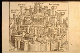
This is the first printed imaginary view of Jerusalem, depicted as a circular walled city dominated by Solomon's Temple. Six of the city gates are named, including David's Gate, also called Gate of the Pisans, after the twelfth-century crusaders from the city of Pisa. This illustration is one of more than 1,800 woodcuts in Liber cronicarum, commonly known in English as the Nuremberg Chronicle, a history of the world from Creation to the time of the volume's publication (1493). It is the most celebrated illustrated book, and, after the Gutenberg Bible, the most important printed book of the fifteenth century. The woodcuts were made in the workshop of Michael Wohlgemut during the apprenticeship of Albrecht Dürer, and it is speculated that Dürer may have participated in their production.

img/flat/jer04.jpg
HARTMANN SCHEDEL
German, 1440-1514
HIEROSOLIMA
From: Liber cronicarum . . .
Nuremberg, 1493
Woodcut, 19.0 x 22.3 cm
Kyram Collection
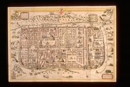
This imaginary plan of Jerusalem and its environs is oriented to the east. It uses a bird's-eye view containing numerous vignettes to create a detailed portrayal of physical features and their associated historic events. Although it purports to represent Jerusalem and its suburbs at the time of Christ, it depicts and identifies 270 sites from both Old and New Testaments. Most important, it delineates for the first time the fourteen Stations of the Cross as they are generally accepted today. The author was a priest and surveyor whose exhaustive studies of the Bible, the writings of Josephus, and early pilgrim narratives enabled him to produce some of the most influential Holy Land maps of the sixteenth century without ever having visited the region. This attractive and highly informative map was widely disseminated and remained the authoritative guide to Jerusalem until the archaeological revelations of the nineteenth century.

img/flat/jer05.jpg
CHRISTIAN VAN ADRICHOM
Dutch, 1533-1585
JERVSALEM et suburbia eius, sicut tempore Christi floruit . . .
From: Jerusalem . . . et suburbanorum . . . brevis descriptio
Köln, 1584
Engraving, hand colored, 52.0 x 74.9 cm
Kyram Collection
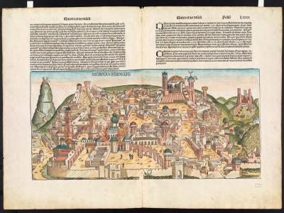
This panoramic view looking westward from the Mount of Olives presents an imaginative composite of the six destructions of Jerusalem described in the associated text of the Nuremberg Chronicle. Solomon's Temple is in flames in the left foreground, and toppled buildings are scattered throughout the city. The Church of the Holy Sepulchre, relatively unscathed, is at the upper center. Calvary is depicted as a separate domed structure at the top right center.

map/237.0001
HARTMANN SCHEDEL
German, 1440-1514
DESTRVCCIO IHEROSOLIME
From: Liber cronicarum . . .
Nuremberg, 1493
Woodcut, hand colored, 25.3 x 53.1 cm
Osher Collection
This is a reproduction of one of the first Crusader maps of the Holy Land, dating from the early twelfth century. It is pictorial in style with east at the top. A disproportionately large schematic depiction of Jerusalem is at the center, surrounded by small images of other cities and topographic features of the Holy Land, crowded into the available space without regard for relative size or scale. Jerusalem is portrayed as a circular walled city in a pattern resembling medieval maps of the world. The city is divided into quarters by two main avenues. The transverse avenue leads from St. Stephen's Gate in the north (at left) to Zion Gate in the south (at right). The vertical avenue connects David's Gate in the west (bottom) with the Temple Mount in the east (top). The major religious sites are portrayed in their approximate locations, with their Crusader names. Small groups of pilgrims are depicted making their way to and from various shrines.

img/flat/unavailable.png
ANONYMOUS
CRUSADER MAP OF JERUSALEM AND PALESTINE
Twelfth Century
Photographic reproduction
Original manuscript 31.3 x 21.0 cm
Bibliothèque Royale de Belgique, Brussels