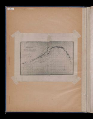
The tracks and landfalls of Bering and Chirikof on the northwest coast of America from the point of separation June 20-21st 1741. Lat 49° 10' N. Long 176° 40' W. (both approx.) to the same meridian on their return June, July, August, Septmeber, October 1741.
Full Title: The tracks and landfalls of Bering and Chirikof on the northwest coast of America from the point of separation June 20-21st 1741. Lat 49° 10' N. Long 176° 40' W. (both approx.) to the same meridian on their return June, July, August, Septmeber, October 1741.
Image Number: 47937.0008

![Notice des planches qui composent L'Atlas de Voyage de Vancouver. [continued]](https://cdn1.historyit.com/iiif/2/5f34291499c4a6.60628694/5cc1fc128cb1d0.16704768.jpg/full/!400,400/0/default.jpg?no_errors=1)