Showing 95131-95140 of 114487 results

Sort By:

Third Map, or Map of 1643. To accompany Willard's History of the United States.
Creator:
Date Created: 1828
Content:
Publisher:
Language:
Region Depicted:
Brief Description: Insets: The four provinces of the New England Confederacy. The commencement of the confederacy, in the union of Plymouth and Massachusetts with New Haven and Connecticut 1643 / Places mentioned in the history of the Pequod War.
Image Number:


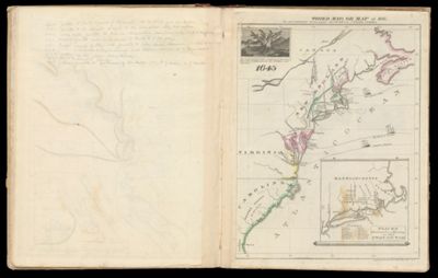
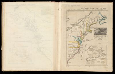
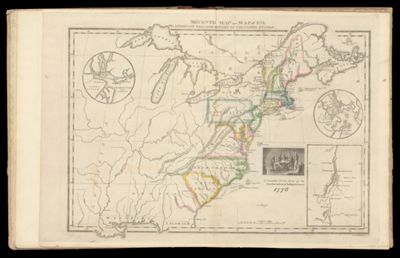
Fourth Map or Map of 1692. To accompany Willard's History of the United States.
Creator:
Date Created: 1828
Content:
Publisher:
Region Depicted:
Brief Description: Includes illustration: "Massachusetts receives a new charter including Maine and other large territories by the arrival of Sir. William Phipps." Also included is the voyage of William Penn arriving in what became Pennsylvania on October 24, 1682. Inset: Places mentioned in the history of King Philip's War.
Image Number:


Text (blank) Page 3
Text (blank) Page 3
Content:
Image Number:


Sixth Map of 1763 To accompany Willard's History of the United States.
Creator:
Date Created: 1828
Content:
Publisher:
Language:
Brief Description: Hand colored outline of the colonies of British America during the French and Indian Wars (1754-1763) against New France. Treaty of Paris signed in 1763 ended the conflict.
Image Number:


Text (blank) Page 4
Text (blank) Page 4
Content:
Image Number:


Seventh Map or Map of 1776. To accompany Willard's History of the United States.
Creator:
Date Created: 1828
Content:
Publisher:
Language:
Brief Description: Insets: Charleston and Vicinity and Boston and Vicinity / A committee of Five draw up the Declaration of Independence in 1776.
Image Number:


Text (blank) Page 5
Text (blank) Page 5
Content:
Image Number:


Eighth map or Map of 1789. To accompany Willard's History of the United States.
Creator:
Date Created: 1828
Content:
Publisher:
Brief Description: Inset of the Constitution signed in 1787. Below: "Federal Government Commencd. 1789". Included are insets of Long Island and Connecticut.
Image Number:


Principal Seat of the Revolutionary War in the Southern Section of the U.S.
Creator:
Date Created: 1828
Content:
Alternative Title: To accompany Willard's History of the United States.
Publisher:
Language:
Region Depicted:
Image Number: