Showing 51-60 of 105 results

Sort By:

Polar regions. Greenland. Antarctic regions.
Creator:
Date Published: 1847
Publisher:
Language:
Dimensions: 17 x 11.5 cm
Image Number:


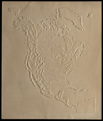
Relief Practice Map North America Revised Edition
Creator:
Publisher:
Language:
Region Depicted:
Map Type:
Dimensions: 26 x 22 cm on sheet 28 x 24 cm
LC Call Number: GA135.K5 1894
OCLC: 793604824
Accession Number: OML-1894-100
Image Number:


Denmark for 20,000 years
Creator:
Publisher:
Language:
Region Depicted:
Map Type:
Dimensions: 84 x 106 cm
LC Call Number: G6916.A5 1969 .A27
OCLC: 4788343
Accession Number: OS-1969-178
Donor:
Donation Date: Oct 26th, 2021
Subjects:
Image Number:


An Arctic outpost : The Greeley Expedition in Discovery Harbor, Greenland.
Date/Date Range Produced: 1882
Language:
Dimensions: H 39.9 x W 27.8 cm
LC Call Number: G3270 .H3 1882
OCLC: 77486922
Accession Number: OS-1882-15
Donor:
Image Number:


Le Canada ou sont La Novelle France, La Nouvelle Angleterre, La Nouvelle Holande, La Nouvelle Svede, La Virginie &c. Avec les Nations voisines et autres Terres nouvellement decouvertes, Suivant les memoires de P. du Val, geographe du Roy.
Creator:
Date/Date Range Produced: 1677
Language:
Region Depicted:
Dimensions: H 44 x W 59.3 cm
Printing Process:
Material Type:
LC Call Number: G3401.S12 D8 1677
OCLC: 76701494
Accession Number: SM-1677-7
Donor:
Image Number:


A General Map of North America from the best Authorities
Creator:
Date/Date Range Produced: 1790
Language:
Region Depicted:
Dimensions: H 21 x W 25.7 cm
Accession Number: SM-1790-25
Donor:
Image Number:


Index to the National Geographic Society's map of Canada, Alaska, and Greenland.
Publisher:
Date Produced: 1947
Language:
LC Call Number: G3400 1947 .N3 Index
OCLC: 182891954
Accession Number: OS-1947-119
Donor:
Donation Date: Mar 1st, 1999
Image Number: