Showing 211-220 of 389 results

Sort By:

Tourist Map of the Boston and Maine Railroad
Creator:
Publisher:
Date/Date Range Produced: 1900
Language:
Region Depicted:
Dimensions: H 36.5 x W 52.4 cm
OCLC: 618229876
Accession Number: OS-1910-43
Donor:
Image Number:


The Smithsonian guides to natural America. Northern New England--Vermont, New Hampshire, and Maine
Author:
Publisher:
Date Produced: 1995
Language:
Dimensions: Height: 20
LC Call Number: E160 .W48 1995
OCLC: 31012614
Accession Number: AUL-1995-26
Donor:
Donation Date: Jan 1st, 2012
Image Number:


Walton's Vermont register, business directory, almanac, and state year-book 1928-29
Publisher:
Date Produced: 1927
Language:
LC Call Number: AY81.F3 W34 1928-29
OCLC: 8168404
Accession Number: CCA,D,M-1928-4
Donor:
Image Number:


Die Staaten von Maine, New Hampshire, Massachusetts, Vermont, Connecticut & Rhode I.
Creator:
Date/Date Range Produced: 1850
Language:
Dimensions: H 30.2 x W 25.8 cm
Printing Process:
Material Type:
LC Call Number: G3730 .M4 1850
OCLC: 244483885
Accession Number: OS-1850-25
Donor:
Image Number:


Central Vermont RY.: Frank H. Clarke, Central Western Passenger Agent, Chicago
Creator:
Language:
Dimensions: 13.5 X 10 cm
Accession Number: OML-18xx-193
Image Number:


A Map of New-England, being the first that ever was here cut, and done by the best pattern that could be had, which being in some places defective, it made the other less exact yet doth it sufficiently shew the scituation of the Country, and conveniently well the distance of Places. The figures that are joyned with the Names of Places are to distinguish such as have been assaulted by the Indians from others.
Creator:
Publisher:
Date/Date Range Produced: 1677
Language:
Region Depicted:
Map Type:
Dimensions: 30 x 38 cm.
Printing Process:
Material Type:
Historical Context: This was the first map to be cut and printed in New England. It was probably designed by William Hubbard to illustrate his account of King Philip's War (1675-76) in "The Present State of New England : Being a narrative of the troubles with the Indians, 1677." The map was printed from a 1677 woodcut by John Foster, who is considered to be North America's first printmaker. The map has a rather primitive appearance and is acknowledged by its maker to be "less exact."

Oriented with North to the right, the map's vertical lines marked the northern and southern boundaries of the Massachusetts Bay Colony as set forth in the 1629 charter. Rhode Island was depicted as a small island near the base of Cape Cod (lower left), and Martha's Vineyard was labeled Martins Vineyard. The Connecticut River stretched across the top of the map, while the Merrimack River dominated the center, sprouted from a large, island-studded lake (Winnepesaukee). Situated to the far right (north) are "The White Hills" of New Hampshire, later rendered as "The Wine Hills" on a second edition of the map engraved and published in London.

Foster associated the territorial region of "New England" with a historical region of conflict between the English and the indigenous peoples. Numbers keyed to a table in the text indicated the locations of massacres and raids on the English. The following occurred in was is now known as Maine (lower right): No. 42, Kittery; No. 47, York; No. 50, Saco River; No. 51, Wells; No. 54, Scarborough; No. 55, Falmouth (now Portland).
OCLC: 733577329
Accession Number: OS-1677-3
See Also:
Donor:
Subjects:
Image Number:


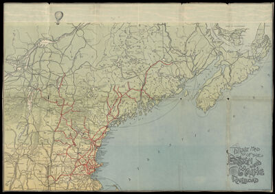
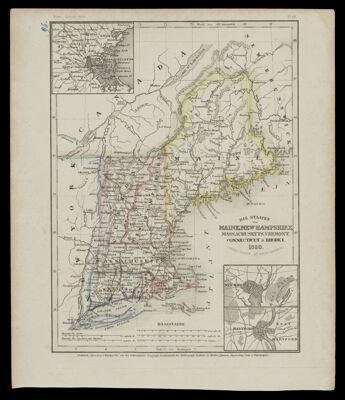
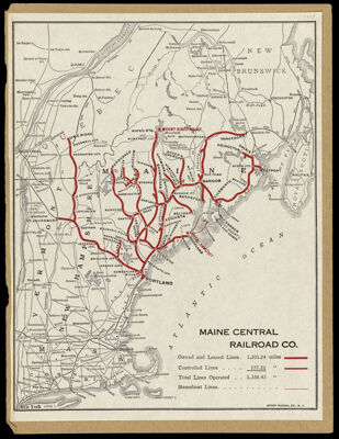
The Official National Survey Maps and Guide for Vermont and New Hampshire Lawton V. Crocker, topographer
Author:
Publisher:
Date Produced: 1926
Language:
Dimensions: Height: 23
Physical Description: 1 book: 171 pages, illustrations, color maps
LC Call Number: G1225 .N3 1926
OCLC: 55629270
Accession Number: OS-1926-14
Donor:
Image Number:


Map of Orange Co., Vermont, scale 3 1/2 miles to the inch, for Child's gazetteer
Publisher:
Date/Date Range Produced: 1888
Language:
Dimensions: 30 x 27 cm
OCLC: 166641041
Accession Number: CCA,D,M-1888-61
Donor:
Image Number:


The official national survey maps and guide for Vermont and New Hampshire Lawton V. Crocker, topographer
Author:
Publisher:
Date Produced: 1926
Dimensions: 16 cm.
Physical Description: 171 p. : ill., col. maps 23 cm
LC Call Number: G1225 .N3 1926 c.2
OCLC: 55629270
Accession Number: OS-1926-101
Donor:
Image Number: